 Filter: Subject of food industry and trade
Filter: Subject of bays
Filter: Subject of food industry and trade
Filter: Subject of bays

| Date: | 1944 |
|---|---|
| Description: | Shows roads, railroads, schools, dairy plants, seaplane bases, wayside parks, and commercial/municipal fields. "Marathon Forms Map Service, Wisconsin repre... |

| Date: | |
|---|---|
| Description: | Exterior of the menu for Paul's Cafe, with a bird's-eye view map of "Washburn's Natural Deep Water Land Locked Harbor," Chequamegon Bay, and the Apostle Is... |
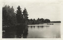
| Date: | |
|---|---|
| Description: | View from Camp Pioneer looking east along the north shore of bay (Lake Raymond, now known as Seventeen Lake). There are piers on the shoreline, and a raft ... |
If you didn't find the material you searched for, our Library Reference Staff can help.
Call our reference desk at 608-264-6535 or email us at: