 Filter: Subject of food industry and trade
Filter: Subject of great lakes
Filter: Subject of food industry and trade
Filter: Subject of great lakes

| Date: | 1835 |
|---|---|
| Description: | Ink on tracing paper map of Green Bay, Wisconsin and nearby areas, Lake Winnebago, Fox and Wolf Rivers, and the junctions of the Mississippi and Wisconsin ... |

| Date: | 1952 |
|---|---|
| Description: | Map of the barley-growing regions of North America, published by the Rahr Malting Company, Manitowoc, Wisconsin, 1952. |

| Date: | 1785 |
|---|---|
| Description: | Map of part of North America engraved and hand-colored (the light brown design is a superposition of the map and cartouche derived from the oxidation of th... |

| Date: | 1923 |
|---|---|
| Description: | This map includes an explanation that reads: "This chart shows the movement of corn on the Great Lakes, St. Lawrence River, and New York State Barge Canal ... |

| Date: | 1851 |
|---|---|
| Description: | This map shows townships, villages, Indian villages, railroads, roads, mills, prairies, swamps, and canals. An inset map shows a plat of the copper distric... |
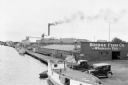
| Date: | 07 1936 |
|---|---|
| Description: | Elevated view of fishing tugs moored alongside the wharf at Marinette. Two automobiles are parked in the foreground, just in front of the Bridge Fish Co. b... |
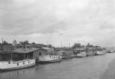
| Date: | 07 1936 |
|---|---|
| Description: | Elevated view of seagulls flying over fishing tugs moored at the wharf in Algoma. Small warehouse buildings line the wharf. Fish net drying reels are visib... |

| Date: | 1935 |
|---|---|
| Description: | View from shoreline towards fishing boats of various sizes, and sailboats docked at the wharf at Fish Creek. Two persons are carrying gear toward the pier.... |
If you didn't find the material you searched for, our Library Reference Staff can help.
Call our reference desk at 608-264-6535 or email us at: