 Filter: Subject of forests and forestry
Filter: Subject of indian reservations
Filter: Subject of forests and forestry
Filter: Subject of indian reservations
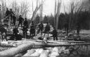
| Date: | 1909 |
|---|---|
| Description: | A group of Native American Indian loggers pose on piles of logs at the Courtes Oreilles Reservation. |

| Date: | 1939 |
|---|---|
| Description: | A color, pictorial map. Scale: 10 miles to the inch. Shows state parks and forests, proposed state parkways, proposed state monuments and memorials, nation... |

| Date: | 1936 |
|---|---|
| Description: | Loading a large white pine log cut on the Menominee Indian Reservation onto a truck. The log was hauled to the Wisconsin State Fair for a display about the... |
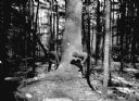
| Date: | 03 1938 |
|---|---|
| Description: | A large white pine being felled on the Menominee Indian Reservation. This photograph was taken to illustrate the tribe's selective logging practices. |
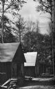
| Date: | 1936 |
|---|---|
| Description: | Exterior view of a logging camp on the Menominee Indian Reservation. The three buildings are surrounded by forest. |

| Date: | 06 1934 |
|---|---|
| Description: | This Wisconsin Conservation Department map shows national, state, and county forests both approved and pending, as well as Indian reservations in Wisconsin... |

| Date: | 1935 |
|---|---|
| Description: | "Drott's conservation guide" map shows the locations of Indian reservations, parks, fish hatcheries, forests, lookout towers, Wisconsin Conservations Commi... |

| Date: | 05 01 1938 |
|---|---|
| Description: | This map shows the locations of Wisconsin Conservation Department forest protection districts and cooperative areas, state forests, national forests, India... |

| Date: | 1939 |
|---|---|
| Description: | This nine-part map from the U.S. Bureau of Public Roads identifies federal and state highways in Wisconsin by pavement type. County, forest, park, and publ... |

| Date: | 1944 |
|---|---|
| Description: | This nine-part map from the U.S. Bureau of Public Roads identifies federal and state highways in Wisconsin by pavement type. County, forest, park, and publ... |

| Date: | |
|---|---|
| Description: | Map of northern Iron County, Wisconsin, shows town sections and railroads in the towns of Saxon, Kimball, and Gurney. It also includes the area of the La P... |

| Date: | 1939 |
|---|---|
| Description: | This illustrated map shows counties, highways, rivers, roads, present and proposed state parks and forests, proposed state parkways, proposed state monumen... |

| Date: | 1975 |
|---|---|
| Description: | This map shows boundaries, roads, national forest land, bogs and wetlands, lakes, campgrounds, and boat landings. |
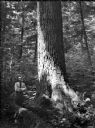
| Date: | 07 1936 |
|---|---|
| Description: | Ray Weber standing next to a large white pine on a Menominee Indian reservation. |
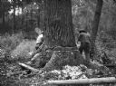
| Date: | 07 1936 |
|---|---|
| Description: | Two men are working together to cut down a large white pine tree on a Menominee Indian reservation. |
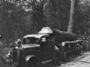
| Date: | 07 1936 |
|---|---|
| Description: | A large, white pine tree is loaded on the back of a truck, ready to be hauled from a Menominee Indian reservation to the Wisconsin State Fair. |

| Date: | |
|---|---|
| Description: | Kodachrome postcard of an aerial view of Lac du Flambeau village and the surrounding chain of lakes. Caption reads: "Lac du Flambeau, Wisconsin." Text on b... |

| Date: | 1950 |
|---|---|
| Description: | A young woman is posing sitting on a boulder on the shoreline along a river rapids. She is holding a walking stick and is wearing a romper. The description... |
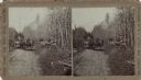
| Date: | |
|---|---|
| Description: | Stereograph of two Menomonee Indian family groups in horse-drawn wagons. One boy is standing next to a wagon and a man is standing on the right holding a g... |
If you didn't find the material you searched for, our Library Reference Staff can help.
Call our reference desk at 608-264-6535 or email us at:
