Filter: Subject of forests and forestry
Filter: Subject of intellectual life
Filter: Subject of forests and forestry
Filter: Subject of intellectual life
| Date: | |
|---|---|
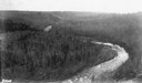
| Description: | Aerial view of the Big Goose Neck in the Bad River at Copper Falls State Park. |

| Date: | 07 10 1949 |
|---|---|
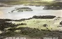
| Description: | Aerial view of Minocqua showing the surrounding lakes. |

| Date: | 1951 |
|---|---|
| Description: | Aerial view of the Nekoosa-Edwards Paper Company nursery. |

| Date: | 1883 |
|---|---|
| Description: | Bird's-eye map of Sauk City. |

| Date: | 1930 |
|---|---|
| Description: | Aerial view of Hoyt Park including the surrounding neighborhoods. Resurrection Cemetery can be seen at the upper right of the image. |

| Date: | 1930 |
|---|---|
| Description: | Aerial view of the University of Wisconsin-Madison Arboretum including a portion of Lake Wingra and surrounding residential neighborhoods. |

| Date: | 1930 |
|---|---|
| Description: | Aerial view of the University of Wisconsin-Madison Arboretum including the surrounding residential neighborhoods. |

| Date: | 1910 |
|---|---|
| Description: | Aerial view of some of the 26 lakes known collectively as the Chain O' Lakes. Caption reads: "Aeroplane View of Chain O'Lakes, Waupaca, Wis." |
| Date: | 1931 |
|---|---|
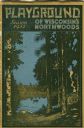
| Description: | Cover of a Wisconsin tourism pamphlet for the 1932 season. |
| Date: | 1926 |
|---|---|
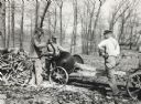
| Description: | Three men use circular saws to cut wood in a forest. The tractor on the right appears to be providing belt-driven power to the saws. |

| Date: | 07 15 1958 |
|---|---|
| Description: | Aerial view of Eagle Heights Farm, Eagle Heights Woods and part of Lake Mendota. Sites labeled on the image are Eagle Heights, Tent Colony, Apartment Site,... |
| Date: | |
|---|---|
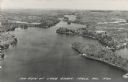
| Description: | Photographic postcard of an aerial view of Lake Owen near Cable. Most of the lake is located within the Chequamegon National Forest. Caption reads: "Air Vi... |
| Date: | 1930 |
|---|---|
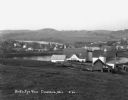
| Description: | View from hill of a farm near a pond. There are homes along the far shoreline, and a lake and hills in the far background. |
| Date: | 1934 |
|---|---|
| Description: | Elevated view of the forest and the two-story Forest Ranger Station with two automobiles parked out front. |

| Date: | |
|---|---|
| Description: | Letterhead of M. Quinn, "Dealer in Pine Lands," with two men in front of a tent at a campsite, one of whom is cooking over a campfire and the other is sitt... |

| Date: | 1930 |
|---|---|
| Description: | Aerial view, looking northeast, across Mud Lake with North Bay in the background, showing cultivated fields and wooded land. |

| Date: | 1930 |
|---|---|
| Description: | Aerial view looking north across the wooded peninsula separating Europe Bay (top) from Newport Bay. This area is now part of Newport State Park. |

| Date: | 1930 |
|---|---|
| Description: | Aerial view of the northern tip of the Door Peninsula, looking north. Europe Lake is in the center, with Europe Bay to the right. Plum Island and Washingto... |

| Date: | 1930 |
|---|---|
| Description: | Aerial view looking northeast, with Rowley's Bay in the foreground. Europe Lake is to the left, with Europe Bay and Newport Bay separated by a narrow peni... |
If you didn't find the material you searched for, our Library Reference Staff can help.
Call our reference desk at 608-264-6535 or email us at: