Filter: Subject of forests and forestry
Filter: Subject of parks
Filter: Subject of forests and forestry
Filter: Subject of parks
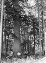
| Date: | |
|---|---|
| Description: | Three men are sitting at the base of a large tree at Flambeau State Forest. |
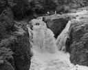
| Date: | |
|---|---|
| Description: | Elevated view of the falls. There are three men at the top of the falls. |

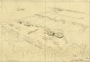
| Date: | 1930 |
|---|---|
| Description: | Aerial view of Hoyt Park including the surrounding neighborhoods. Resurrection Cemetery can be seen at the upper right of the image. |
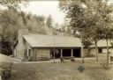
| Date: | 1939 |
|---|---|
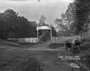
| Description: | The shelter house at Copper Falls State Park. |
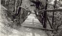
| Date: | 07 1937 |
|---|---|
| Description: | View down picturesque suspension bridge across one of the gullies at Copper Falls State Park. |
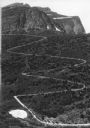
| Date: | |
|---|---|
| Description: | Elevated view of a donkey train going up a zig-zag trail along the mountainside in Glacier National Park. |
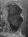
| Date: | 1920 |
|---|---|
| Description: | A large, balancing boulder in Paradise Park, Ohio. A man is posed standing on the left side of the rock and a woman is posed standing on the right side of ... |
| Date: | |
|---|---|
| Description: | A view of the main entrance to Putnam Park, including two wooden towers on either side of the road, various cannons and cannon balls. There is a swing set ... |

| Date: | |
|---|---|
| Description: | Park with stone-lined waterways, surrounded by woods. In the middle of the image is a small island with a rustic stone hut and in the background are stone... |

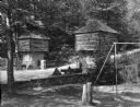
| Date: | |
|---|---|
| Description: | A small group sits under an ivy-covered arbor which covers what appears to be a fresh water well. The arbor is set in the woods and bears a horse-shoe shap... |

| Date: | |
|---|---|
| Description: | View of the circle swing at Waldemeer Park. The ride is surrounded by a fence, trees, and several power lines. |
| Date: | |
|---|---|
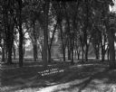
| Description: | View down dirt path through a wooded area. Beyond the trees are houses and buildings. |
| Date: | 1925 |
|---|---|
| Description: | The entrance to the Carthwaite Park tourist camp and picnic grounds. There is a sign for a filling station 1 mile ahead. A car is parked inside the grounds... |
| Date: | |
|---|---|
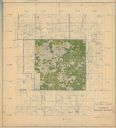
| Description: | This hand-colored map shows the Ranger District boundaryin blue, government lands in green, and "Opt. 9 Appr. Land" in yellow. |

| Date: | 1933 |
|---|---|
| Description: | A road map of Wisconsin and Michigan’s Upper Peninsula, showing the populations of cities and villages, state and federal highways, national forests, state... |

| Date: | 1935 |
|---|---|
| Description: | "Drott's conservation guide" map shows the locations of Indian reservations, parks, fish hatcheries, forests, lookout towers, Wisconsin Conservations Commi... |

| Date: | 1939 |
|---|---|
| Description: | This nine-part map from the U.S. Bureau of Public Roads identifies federal and state highways in Wisconsin by pavement type. County, forest, park, and publ... |

| Date: | 1944 |
|---|---|
| Description: | This nine-part map from the U.S. Bureau of Public Roads identifies federal and state highways in Wisconsin by pavement type. County, forest, park, and publ... |

| Date: | 1970 |
|---|---|
| Description: | Color coded map. Legend in the top left hand corner reads: "EXISTING AIRPORT PAVEMENT" (purple), "FUTURE 5-YEAR DEVELOPMENT" (bright pink), "ULTIMATE AIRPO... |
If you didn't find the material you searched for, our Library Reference Staff can help.
Call our reference desk at 608-264-6535 or email us at: