Filter: Subject of forests and forestry
Filter: Subject of rivers
Filter: Subject of forests and forestry
Filter: Subject of rivers
| Date: | |
|---|---|
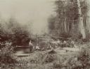
| Description: | Fisherman cooking on campfire at the edge of a river. |
| Date: | |
|---|---|
| Description: | View from shoreline towards eight men trout fishing on the Brule River. |

| Date: | 10 1852 |
|---|---|
| Description: | Landscape view of the river looking downstream from Fort Snelling, Minnesota Territory. An expanse of placid river water fills the center of the drawing an... |
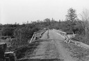
| Date: | 06 01 1936 |
|---|---|
| Description: | Bridge and truck trail constructed by Works Progress Administration (WPA) workmen to facilitate forest fire prevention and control. |
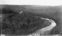
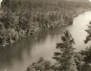
| Date: | |
|---|---|
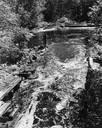
| Description: | Aerial view of the Big Goose Neck in the Bad River at Copper Falls State Park. |

| Date: | 1951 |
|---|---|
| Description: | Aerial view of the Nekoosa-Edwards Paper Company nursery. |
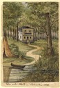
| Date: | 1858 |
|---|---|
| Description: | This house, built on a hill close to the Milwaukee River, was the only one in the city as late as 1840. The owner of the house, Martin [Matthias] Stein, a ... |

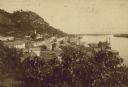
| Date: | 1902 |
|---|---|
| Description: | River with distant hills behind a town. An island is in the foreground. |
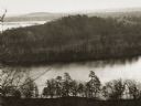
| Date: | |
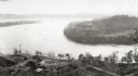
|---|---|
| Description: | Elevated view of the "mount" and the wide river before it and behind it. Houses and smokestacks can be seen in the far distance. |
| Date: | |
|---|---|
| Description: | Elevated view of a bow in the river, and a homestead on the shore, with a two-story house and a barn. Two wagons are close to the barn in the lower left co... |
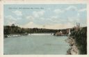
| Date: | |
|---|---|
| Description: | View of the mill and the dam, and the river. The area around the mill is heavily forested. Caption reads: "Dells Paper Mill and Dam, Eau Claire, Wis." |
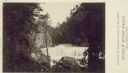
| Date: | 1880 |
|---|---|
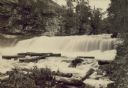
| Description: | Willow River Falls. Text at right reads: "Published by Whitney's Gallery, St. Paul, Minn. Willow River Falls Near Hudeson, Wis." |
| Date: | |
|---|---|
| Description: | Elevated view form hill of the town of Victory on the bank of a river. |
| Date: | 1940 |
|---|---|
| Description: | Elevated view of a canoe on the St. Croix River with wooded areas on both sides within the Interstate State Park. Established in 1900, Interstate Park was... |

| Date: | 1910 |
|---|---|
| Description: | Aerial view of some of the 26 lakes known collectively as the Chain O' Lakes. Caption reads: "Aeroplane View of Chain O'Lakes, Waupaca, Wis." |

| Date: | 1939 |
|---|---|
| Description: | A color, pictorial map. Scale: 10 miles to the inch. Shows state parks and forests, proposed state parkways, proposed state monuments and memorials, nation... |
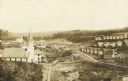
| Date: | 1910 |
|---|---|
| Description: | An elevated view of town. A church is on the left, houses are in rows on the right. Caption reads: "Made-For-Club-House — Niagara-Wis.—". |

| Date: | 1900 |
|---|---|
| Description: | Group of four standing on the rocks along shore of the Wisconsin River at the Wisconsin Dells. |
If you didn't find the material you searched for, our Library Reference Staff can help.
Call our reference desk at 608-264-6535 or email us at: