 Filter: Subject of forests and forestry
Filter: Subject of streets
Filter: Subject of forests and forestry
Filter: Subject of streets

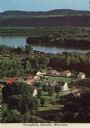
| Date: | 07 10 1949 |
|---|---|
| Description: | Aerial view of Minocqua showing the surrounding lakes. |
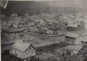
| Date: | 1886 |
|---|---|
| Description: | Elevated view of houses and buildings in Wonewoc. |

| Date: | 1972 |
|---|---|
| Description: | Aerial view of commercial buildings and dwellings along the shore of Lake Michigan. Caption reads: "Baileys Harbor, Wisc." |

| Date: | |
|---|---|
| Description: | The log who was made King of Logs is here entombed eight round, ten long For his design, the strengthened forest capriciously outgrew them all... |
| Date: | |
|---|---|
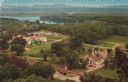
| Description: | Elevated view of Stonefield Village, with the Mississippi River in the background. Caption reads: "Stonefield, Cassville, Wis." |
| Date: | |
|---|---|
| Description: | Color postcard of an elevated view of Stonefield Village with the Mississippi River in the background and railroad tracks in the foreground. |

| Date: | 1858 |
|---|---|
| Description: | This map shows city wards, streets, block and lot numbers, cemeteries, buildings, landownership, forests, railroads, a race course, quarries, and orchards.... |

| Date: | 1776 |
|---|---|
| Description: | Fairly detailed map of New York City and parts of Long Island. It shows streets, roads, wharves, ferries, ship yards, Fort George and the battery, public b... |

| Date: | 1759 |
|---|---|
| Description: | Map of New Orleans at the start of the French & Indian War, including two inset maps entitled "The Course of the Mississipi River from Bayagoulas to the Se... |

| Date: | 1769 |
|---|---|
| Description: | Map of New Orleans at the start of the French & Indian War, including two inset maps of the Mississippi River Delta and Fort la Balise. It shows streets, r... |

| Date: | 1761 |
|---|---|
| Description: | Map of New Orleans with north oriented towards the upper right corner. It shows the land around the city, the Mississippi River, anchorages, roads leading ... |

| Date: | 06 12 1958 |
|---|---|
| Description: | The new headquarters of the Forest Products Research Society located at 1 Walnut Street. |
If you didn't find the material you searched for, our Library Reference Staff can help.
Call our reference desk at 608-264-6535 or email us at: