 Filter: Subject of forests and forestry
Filter: Subject of tourism
Filter: Subject of forests and forestry
Filter: Subject of tourism
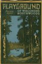
| Date: | 1931 |
|---|---|
| Description: | Cover of a Wisconsin tourism pamphlet for the 1932 season. |
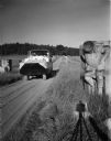
| Date: | 08 15 1955 |
|---|---|
| Description: | Amphibious Duck on land with Board of Trade stone works. The stone gargoyles were salvaged from the Board of Trade building in Chicago by Newman. |
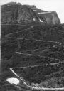
| Date: | |
|---|---|
| Description: | Elevated view of a donkey train going up a zig-zag trail along the mountainside in Glacier National Park. |

| Date: | 1958 |
|---|---|
| Description: | Includes images of Flambeau River State Forest and a description of, canoeing and recreational activities in, and general park and forest information about... |

| Date: | 1935 |
|---|---|
| Description: | This pictorial map of northern Bayfield County, Wisconsin, shows the Chequamegon National Forest, the Red Cliff Indian Reservation, highways and roads, and... |

| Date: | 1960 |
|---|---|
| Description: | This mid-20th century tourist brochure for Bayfield County, Wisconsin, includes a map of the county showing towns, cities and villages, highways and roads,... |

| Date: | 1967 |
|---|---|
| Description: | This tourist brochure for Bayfield County, Wisconsin, from 1967 includes a map of the county showing towns, cities and villages, highways and roads, railro... |
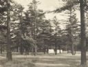
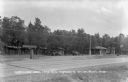
| Date: | 1925 |
|---|---|
| Description: | Stand of pine trees and pitched tents, with automobiles, in the Marinette Tourist Camp. |

| Date: | 1926 |
|---|---|
| Description: | Elevated scenic view of the Wisconsin River with rock formations along the shoreline. |

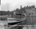
| Date: | 1927 |
|---|---|
| Description: | The Ravenswood beach on the Wisconsin River. A man is piloting an excursion boat as it is pulling away from the shoreline. Two rowboats are pulled up on th... |
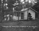
| Date: | |
|---|---|
| Description: | Two small guest cottages surrounded by woods. Both cottages have screened-in porches. |

| Date: | |
|---|---|
| Description: | View of the Wisconsin River, with a beach on the left. In the distance is a tree-covered hill. |

| Date: | 1926 |
|---|---|
| Description: | View across Wisconsin River of tree-covered bluffs along the shoreline. |
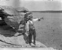
| Date: | 1929 |
|---|---|
| Description: | Native American tour guide standing on a rock formation. He is wearing a headdress and decorated vest and white shirt, and is holding a megaphone and point... |
| Date: | 1929 |
|---|---|
| Description: | Native American guide in native dress standing on the bow of a tour boat floating in the river. A pilot wearing a hat is sitting behind him. On the front o... |
| Date: | |
|---|---|
| Description: | View from other side of road towards the Continental Cabin Camp and Texaco station along Highway 12. There are people standing near two parked cars. |

| Date: | 1939 |
|---|---|
| Description: | This illustrated map shows counties, highways, rivers, roads, present and proposed state parks and forests, proposed state parkways, proposed state monumen... |

| Date: | 1980 |
|---|---|
| Description: | This map shows the locations of 42 businesses, roads, points of interest, recreation sites, camping, the North Country Trail and parking, and boundaries of... |

| Date: | 1935 |
|---|---|
| Description: | This map shows rivers, lakes, communities, woods, fishing locations, and vacation destinations. The back of the map includes text about agricultural, sceni... |

| Date: | 1966 |
|---|---|
| Description: | This map includes a red overprint on base map and shows the supervisors and district numbers of St. Croix County. Includes diagrams of civil towns, townsh... |
If you didn't find the material you searched for, our Library Reference Staff can help.
Call our reference desk at 608-264-6535 or email us at: