 Filter: Subject of gasoline industry
Filter: Subject of camping
Filter: Subject of gasoline industry
Filter: Subject of camping
| Date: | |
|---|---|
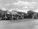
| Description: | A small gasoline station and refreshment station advertising distilled water, hot dogs, hamburgers, groceries, coffee, and other products. Near the station... |
| Date: | 1925 |
|---|---|
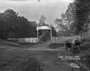
| Description: | The entrance to the Carthwaite Park tourist camp and picnic grounds. There is a sign for a filling station 1 mile ahead. A car is parked inside the grounds... |

| Date: | 1943 |
|---|---|
| Description: | This map shows roads, trails, taverns, schools, golf, gas stations, campsites, resorts, and towers. The lower left of the map includes a legend. The map co... |

| Date: | 1925 |
|---|---|
| Description: | The map shows the entire state with portions of Illinois, Iowa, Minnesota, and Michigan. The map shows concrete, gravel, all weather earth, clay, and sand ... |
If you didn't find the material you searched for, our Library Reference Staff can help.
Call our reference desk at 608-264-6535 or email us at: