 Filter: Subject of gasoline industry
Filter: Subject of tourism
Filter: Subject of gasoline industry
Filter: Subject of tourism
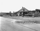
| Date: | 1937 |
|---|---|
| Description: | Corner of Broadway and Superior, with Texaco station and Olson Boat Ticket kiosk. |
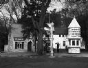
| Date: | |
|---|---|
| Description: | Exterior of a gas station/restaurant and the entrance to the Triangle Tourist Park. |

| Date: | 1930 |
|---|---|
| Description: | This map features a legend of highways, railroads, parks, and service stations. The cover and inside of the map features pictures of attractions in Madison... |

| Date: | 1943 |
|---|---|
| Description: | This map shows roads, trails, taverns, schools, golf, gas stations, campsites, resorts, and towers. The lower left of the map includes a legend. The map co... |
If you didn't find the material you searched for, our Library Reference Staff can help.
Call our reference desk at 608-264-6535 or email us at: