 Filter: Subject of gasoline industry
Filter: Subject of water
Filter: Subject of gasoline industry
Filter: Subject of water
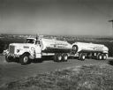
| Date: | 1950 |
|---|---|
| Description: | A man is driving an International W-4064-L owned by Eastern Washington Transports, Inc. up an inclined road. An elevated view of an urban area, probably Se... |
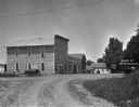
| Date: | 1921 |
|---|---|
| Description: | View down unpaved road of a filling station. Along the side of the station on the left is a hand-pump, and a large tank lying on its side. Three buildings ... |
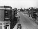
| Date: | 1930 |
|---|---|
| Description: | Elevated view of High Street (Highway 96) and the bridge over the Fox River at Wrightstown. Farmers & Traders Bank is at left, a sign for Meuleman's Elect... |

| Date: | 1930 |
|---|---|
| Description: | This map features a legend of highways, railroads, parks, and service stations. The cover and inside of the map features pictures of attractions in Madison... |
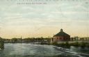
| Date: | 1909 |
|---|---|
| Description: | Colorized photographic postcard of the Gas Company's building along the river in Eau Claire. Caption reads: "Gas Co's Building, Eau Claire, Wis." |

| Date: | 1930 |
|---|---|
| Description: | This map shows city wards, streets, railroads, parks, Lake Butte Des Morts, Lake Winnebago, advertisements for Dixie Oils Gasoline, a list of Cook & Brown ... |

| Date: | 1943 |
|---|---|
| Description: | This map shows roads, trails, taverns, schools, golf, gas stations, campsites, resorts, and towers. The lower left of the map includes a legend. The map co... |

| Date: | 1927 |
|---|---|
| Description: | This map details automobile routes throughout the state as well as parts of Iowa, Minnesota, Michigan and Illinois. Cities, the Mississippi River, Lake Mic... |

| Date: | 1925 |
|---|---|
| Description: | The map shows the entire state with portions of Illinois, Iowa, Minnesota, and Michigan. The map shows concrete, gravel, all weather earth, clay, and sand ... |

| Date: | 1932 |
|---|---|
| Description: | This map shows automobile routes across Wisconsin and parts of Illinois, Michigan, Minnesota and Iowa. The Mississippi River, Lake Michigan, Lake Superior,... |

| Date: | 1935 |
|---|---|
| Description: | This road map shows automobile routes across the state of Wisconsin. Advertisements for various hotels are featured along the bottom edge of the map, while... |
If you didn't find the material you searched for, our Library Reference Staff can help.
Call our reference desk at 608-264-6535 or email us at: