 Filter: Subject of geology
Filter: Subject of land
Filter: Subject of geology
Filter: Subject of land
| Date: | |
|---|---|
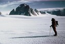
| Description: | Unidentified explorer standing in field of snow with the Horlick Mountains of Antarctica in the background. The Horlick Mountains were named by Admiral Ric... |

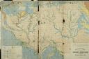
| Date: | 1865 |
|---|---|
| Description: | Map showing the location of meteorological stations and effects that Lake Michigan has had on Wisconsin temperatures in January and July. The map shows cou... |
| Date: | |
|---|---|
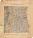
| Description: | Geological Map of the lead regions in Wisconsin, Illinois and Iowa. |

| Date: | 1920 |
|---|---|
| Description: | This map identifies the areas of the state that had been geologically surveyed or topographically surveyed, or both, as well as portions of the state still... |

| Date: | 1852 |
|---|---|
| Description: | Hand-colored maps and a series of geological cross sections of the Mississippi River between the Falls of St. Anthony and the mouth of the Wisconsin River ... |

| Date: | 1873 |
|---|---|
| Description: | A hand-colored, geological map of the Fox and Wisconsin rivers’ water path from the Mississippi River to the Great Lakes. The map also shows those railroad... |
| Date: | 1876 |
|---|---|
| Description: | This color-coded map of the geology of southeastern Wisconsin shows the township grid, counties, towns, cities and villages, rivers, lakes, and railroads. ... |

| Date: | 1912 |
|---|---|
| Description: | This map is pen, ink, and pencil on tracing paper. The map was traced from U.S. Geological Survey map of Wisconsin, compiled in 1910-1911, and printed in 1... |

| Date: | 1937 |
|---|---|
| Description: | A pictorial, hydrographic map shows sailing courses, historical and contemporary coastal attractions, roads, and the contour depths of Green Lake, Wisconsi... |

| Date: | 1836 |
|---|---|
| Description: | A detailed map of the mouth of the Kewaunee River, showing the geological composition of the Lake Michigan shoreline and the various water depths in the ar... |

| Date: | 1828 |
|---|---|
| Description: | Drawing by Increase Lapham showing the geological profile of the land between Utica and Knob Creek, Kentucky at a scale of 1/2 inch to a mile. |

| Date: | 12 22 1830 |
|---|---|
| Description: | Increase Lapham's drawing of the geological profile between the Sandusky plains and Portsmouth, Ohio. |
| Date: | 1844 |
|---|---|
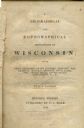
| Description: | Title page of Increase Lapham's A Geographical and Topographical Description of Wisconsin published by P.C. Hale of Milwaukee, Wisconsin. |

| Date: | 1902 |
|---|---|
| Description: | This map is watercolor and pen on paper and relief shown by contours. The map reads: "Contour interval 10 feet." Shown on the map are geological features a... |

| Date: | 1883 |
|---|---|
| Description: | This map shows the geology of areas in Montana, the Dakotas, Nebraska, Wyoming, Idaho, Colorado, Kansas, Arizona, New Mexico, and Utah. Map also shows lake... |

| Date: | 1892 |
|---|---|
| Description: | This map shows rivers, lakes, railroad lines, roads, and communities in addition to geological data. The map includes cross-sections in the bottom margin a... |

| Date: | 1864 |
|---|---|
| Description: | This map is pen and watercolor on paper and shows a profile and geological sections of the Blue Mounds, Hollow Run, Bogies Hollow Run, Bear Creek, East Bre... |

| Date: | 1864 |
|---|---|
| Description: | This map is pen and watercolor on paper and shows a profile and geological sections of the Spensley Break, James Break, Wisconsin River, and Little Bear Cr... |

| Date: | 1864 |
|---|---|
| Description: | This map is pen and pencil on paper and shows a profile of the Blue Mound and East Blue Mound. |

| Date: | 1864 |
|---|---|
| Description: | This map is pen and watercolor on paper and shows a profile and the geological formation of Blue Mound. Also shown is the location of Arnold's Hotel and Br... |
If you didn't find the material you searched for, our Library Reference Staff can help.
Call our reference desk at 608-264-6535 or email us at: