 Filter: Subject of golf
Filter: Subject of boats and boating
Filter: Subject of golf
Filter: Subject of boats and boating
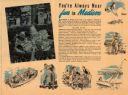
| Date: | 1960 |
|---|---|
| Description: | Views of popular sites in Madison. Numerous different types of recreation are depicted, along with popular sites such as the Wisconsin State Capitol buildi... |

| Date: | 1930 |
|---|---|
| Description: | Pictorial map of Glacier National Park, Montana and Waterton Lakes National Park, Alberta. Illustrated by Joe Scheurle, it depicts white people, American ... |

| Date: | 1930 |
|---|---|
| Description: | The back of the pictorial map titled Recreational Map of Glacier National Park, Montana: Waterton Lakes National Park, Alberta. 14 panels of text and photo... |

| Date: | 1936 |
|---|---|
| Description: | This pictorial tourist map from the Wisconsin Conservation Commission depicts vacation activities and identifies tourist destinations throughout the state.... |

| Date: | 1975 |
|---|---|
| Description: | A tourist map of Grant County that displays the various activities and attractions found in the cities throughout the county, such as boat landings, fishin... |

| Date: | 1962 |
|---|---|
| Description: | This map shows roads, golf courses, ski areas, boat landings, camp sites, waysides, parks, beaches, scenic views, virgin timber tracts, airports, boys and ... |

| Date: | 1962 |
|---|---|
| Description: | This map shows roads, golf courses, ski areas, boat landings, camp sites, waysides, parks, beaches, scenic views, virgin timber tracts, airports, boys and ... |

| Date: | 1990 |
|---|---|
| Description: | This map shows various types of trails, boat landings, canoe areas, public beaches, picnic areas, campgrounds, golf courses, public tennis courts, and othe... |

| Date: | 1969 |
|---|---|
| Description: | A woman getting ready to putt on the green at the Peninsula State Park Golf Course. A man stands on the left watching, and parked behind him is a golf cart... |

| Date: | |
|---|---|
| Description: | The non-mailing side of a wrap-around postcard cover. Glued inside is a folded series of two sided scenes of attractions in Central Wisconsin. Across the i... |
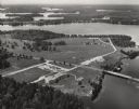
| Date: | 1950 |
|---|---|
| Description: | Aerial view of Northernaire Resort, on Deer Lake. The resort is in the foreground. Many lakes, surrounded by trees, are in the background, including Big St... |
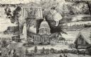
| Date: | |
|---|---|
| Description: | Cartoon drawing of people playing golf and other games, relaxing, sitting on the beach and swimming and boating on the lake. The building in the center is ... |
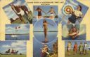
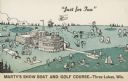
| Date: | 08 22 1955 |
|---|---|
| Description: | Text on front reads: "Summer Sports at Northernarie, Three Lakes, Wisconsin." On reverse: "Northernarie Hotel and Spa. Three Lakes, Wis. Truly one of Ameri... |
| Date: | |
|---|---|
| Description: | This map of Madison is also a brochure of activities for vacationers in the area. Includes indexes and some points of interest shown pictorially. |
If you didn't find the material you searched for, our Library Reference Staff can help.
Call our reference desk at 608-264-6535 or email us at: