 Filter: Subject of golf
Filter: Subject of school buildings
Filter: Subject of golf
Filter: Subject of school buildings

| Date: | 1966 |
|---|---|
| Description: | This 1966 map shows topography, roads, highways, golf courses, government buildings, and businesses around Delavan Lake in Walworth County, Wisconsin. Incl... |
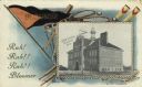
| Date: | 1908 |
|---|---|
| Description: | Photographic postcard featuring an illustration of the high school, bordered by a pennant, a baseball bat, golf clubs, rowing oars and tennis rackets. Capt... |

| Date: | 1960 |
|---|---|
| Description: | This blue line print shows state and city maintained roads, as well as government land, parks, Milwaukee Co. Park Commission, golf courses, schools, City o... |
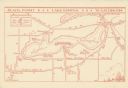
| Date: | 1935 |
|---|---|
| Description: | This map shows Black Point estate including buildings and signs, as well as a school and store near the village of Linton, country clubs, roads, Yerkes Obs... |
If you didn't find the material you searched for, our Library Reference Staff can help.
Call our reference desk at 608-264-6535 or email us at: