 Filter: Subject of golf
Filter: Subject of tennis
Filter: Subject of golf
Filter: Subject of tennis

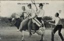
| Date: | 1916 |
|---|---|
| Description: | Three men ride a dairy cow on a dirt road, while a fourth pulls at the cow's tail. Of the three men, one is holding a tennis racket, one is holding a golf ... |
| Date: | 1916 |
|---|---|
| Description: | Three men ride a dairy cow on a dirt road, while a fourth pulls at the cow's tail. Of the three men, one is holding a tennis racket, one is holding a golf ... |

| Date: | 1930 |
|---|---|
| Description: | Pictorial map of Glacier National Park, Montana and Waterton Lakes National Park, Alberta. Illustrated by Joe Scheurle, it depicts white people, American ... |

| Date: | 1930 |
|---|---|
| Description: | The back of the pictorial map titled Recreational Map of Glacier National Park, Montana: Waterton Lakes National Park, Alberta. 14 panels of text and photo... |

| Date: | 03 11 1954 |
|---|---|
| Description: | Group portrait of three women posing in athletic clothing with sports equipment in hand. They are, from left, Ruth Ward holding a tennis raquet, Ruth Edie ... |
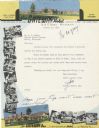
| Date: | |
|---|---|
| Description: | Letterhead of the King's Gateway Hotel in Land O' Lakes, Wisconsin, with header and footer views of the hotel and nearby Gateway Inn in color, and overlapp... |
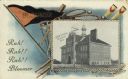
| Date: | 1908 |
|---|---|
| Description: | Photographic postcard featuring an illustration of the high school, bordered by a pennant, a baseball bat, golf clubs, rowing oars and tennis rackets. Capt... |
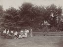
| Date: | 1898 |
|---|---|
| Description: | Dousman family entertaining house guests on the lawn at Villa Louis. A table and chairs are set up on the grass and several of the group are holding baseba... |

| Date: | 1990 |
|---|---|
| Description: | This map shows various types of trails, boat landings, canoe areas, public beaches, picnic areas, campgrounds, golf courses, public tennis courts, and othe... |
If you didn't find the material you searched for, our Library Reference Staff can help.
Call our reference desk at 608-264-6535 or email us at: