 Filter: Subject of human settlements
Filter: Community of Gettysburg
Filter: Subject of human settlements
Filter: Community of Gettysburg
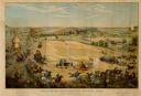
| Date: | 1886 |
|---|---|
| Description: | Color lithographed color advertising poster showing a McCormick grain binder at the Civil War battle of Gettysburg. The poster was based on a cyclorama by ... |
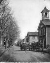
| Date: | |
|---|---|
| Description: | View toward the fire engine which is parked in the middle of the street. To the right, parked next to the curb, is the wagon that carries the fire fighters... |
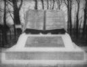
| Date: | 1890 |
|---|---|
| Description: | "Commands Honored" monument in the form of a large bronze book opened to pages reading "High Water Mark on the Rebellion" and "Repulse of Longstreet's Assa... |

| Date: | 1864 |
|---|---|
| Description: | This map of the Battle of Gettysburg indicates Union positions in red and Confederate positions in blue. Also shown are artillery positions, roads, railroa... |

| Date: | 1876 |
|---|---|
| Description: | Detailed topographic map of the Gettysburg battlefield created thirteen years after the battle. This map shows day one of the battle. The map shows drainag... |

| Date: | 1863 |
|---|---|
| Description: | These detailed topographical maps of the Battle of Gettysburg show drainage, vegetation, roads, railroads, fences, houses with names of residents, and a de... |

| Date: | 1863 |
|---|---|
| Description: | These detailed topographical maps of the Battle of Gettysburg show drainage, vegetation, roads, railroads, fences, houses with names of residents, and a de... |

| Date: | 1863 |
|---|---|
| Description: | This map shows drainage, vegetation, roads, railroads, fences, dwellings with names of inhabitants, and land owned by the United States. Union and Confeder... |
If you didn't find the material you searched for, our Library Reference Staff can help.
Call our reference desk at 608-264-6535 or email us at: