 Filter: Subject of human settlements
Filter: Community of Westfield
Filter: Subject of human settlements
Filter: Community of Westfield

| Date: | 1915 |
|---|---|
| Description: | View toward the church on the left. Another building is in the background on the right. Caption reads: "Church at Westfield, Wis." |

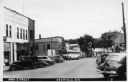
| Date: | 1905 |
|---|---|
| Description: | A view down the sidewalk with storefronts on the right. Pedestrians are standing on the sidewalk, and horse-drawn vehicles are along the curb. Caption read... |

| Date: | 1915 |
|---|---|
| Description: | Looking across Mill Pond towards buildings along the shoreline. Caption reads: "Mill Pond, Westfield, Wis." |
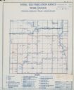
| Date: | |
|---|---|
| Description: | Rural electrification survey map of Marquette county in Westfield township. |

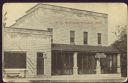
| Date: | 2008 |
|---|---|
| Description: | Located at 627 Main Street, Theo Bertin built this small house-and-canopy station hoping to transform travelers driving north along old Highway 51 into cus... |

| Date: | 09 28 1907 |
|---|---|
| Description: | Text on front reads: "M.E. Church, Westfield, Wis." A Methodist Episcopal Church with a belfry, built in 1865 of clapboard in the Gothic revival style. The... |

| Date: | 07 13 1910 |
|---|---|
| Description: | Text on front reads: "The Dam – Westfield, Wis." Water spills over the dam into the river, and buildings are behind and above the dam. There are trees on b... |
| Date: | 1945 |
|---|---|
| Description: | Text on front reads: "Main Street, Westfield, Wis." Many automobiles and a Greyhound Bus are diagonally parked on Main Street. The destination sign on the ... |
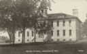
| Date: | 05 30 1932 |
|---|---|
| Description: | Text on front reads: "Grade School, Westfield, Wis." Originally built in 1887, the grade school students were downstairs and the high school students upsta... |
| Date: | 07 27 1912 |
|---|---|
| Description: | Text on front reads: "Hotel Hammond, Westfield, Wis." A two-story hotel built of concrete block with a covered porch. Later it was called the Hotel Westfie... |
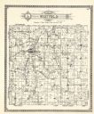
| Date: | 1922 |
|---|---|
| Description: | A plat map by Westfield created by George A. Ogle & Co. |
If you didn't find the material you searched for, our Library Reference Staff can help.
Call our reference desk at 608-264-6535 or email us at: