 Filter: Subject of industry
Filter: Subject of ferries
Filter: Subject of industry
Filter: Subject of ferries
| Date: | |
|---|---|
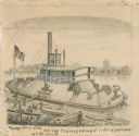
| Description: | "Ferry 'New Era' being transformed into a gunboat at St. Louis." Drawing includes workers building with lumber. |
| Date: | 1969 |
|---|---|
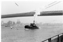
| Description: | The Island's Edge, Williamsburg Bridge, East River. |
| Date: | |
|---|---|
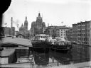
| Description: | Elevated view of two Goodrich Line passenger ferries docked on the west bank of the Milwaukee River, north of the Clybourn Street bridge. The Pabst buildin... |
| Date: | |
|---|---|
| Description: | Elevated view of the "City of Charlevoix" ship coming into harbor. The sign painted on the front of the ship reads: "Northern Michigan Line" and "City of C... |

| Date: | 12 17 1957 |
|---|---|
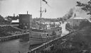
| Description: | Carferry slip with pilings in the foreground, and a shoreline in the background. The pier is made of timbers. In the background on the left is a factory wi... |

| Date: | 1933 |
|---|---|
| Description: | This map shows the major highways and freeways of Wisconsin as well as road surfaces, state parks, points of interest, ferry routes, bridges, and towns whe... |

| Date: | 1936 |
|---|---|
| Description: | This map shows road surfaces, construction, flying fields, seaplane landings, populations of cities and towns, and ferry routes of Wisconsin and some of th... |

| Date: | 1936 |
|---|---|
| Description: | This colored road map shows automobile roads in Wisconsin as well as portions of Michigan, Iowa, Minnesota, and Illinois. U.S. numbered highways are shown ... |
If you didn't find the material you searched for, our Library Reference Staff can help.
Call our reference desk at 608-264-6535 or email us at: