Filter: Subject of industry
Filter: Subject of grist mills
Filter: Subject of industry
Filter: Subject of grist mills
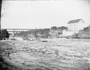
| Date: | |
|---|---|
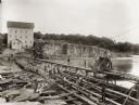
| Description: | Several men on a raft going over the dam at Munger's Mill. There is a railroad bridge in the background. |
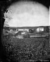
| Date: | 1875 |
|---|---|
| Description: | View, through a cornfield, of people, a store, a sawmill and wagons. Moscow was platted in 1850 by an Englishman, Chauncy Smith, who dammed the Bluemound ... |
| Date: | 1885 |
|---|---|
| Description: | View of the Rockdale mill, a grist and sawmill built in 1847 by Thomas and Nathan Van Horn. A group of people are standing on a sidewalk or loading dock on... |
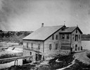
| Date: | 04 1923 |
|---|---|
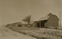
| Description: | Lappley Feed Mill and lumberyard. Caption reads: "Lappley Feed Mill and Lumber Yard Fitchburg, Wis." |
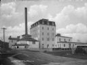
| Date: | 1963 |
|---|---|
| Description: | H.P. Christ Feed Mill. The first building across the street is the Atlas Hotel which was located at the site of the present Milo Howarth senior home. Other... |
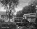
| Date: | 1895 |
|---|---|
| Description: | Munger's Mill and dam, with men standing on and around the dam. |
| Date: | |
|---|---|
| Description: | Group of four men and a girl standing on the opposite shoreline by the falls, with probably the Charter Oak Mill on the right on Squaw Creek. |
| Date: | |
|---|---|
| Description: | A view of a grist mill and sawmill with a waterfall between them. Caption reads: "Grist and Saw Mill." |
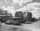
| Date: | 1960 |
|---|---|
| Description: | Exterior of Olsen's Mill (Wayne Feeds) on Hwy 49, just north of Hwy 21. |

| Date: | 1914 |
|---|---|
| Description: | Map shows school houses, creameries, post offices, saw mills, grist mills, churches, cemeteries, town halls, stores, roads, state roads, and railroads. "Co... |

| Date: | 1842 |
|---|---|
| Description: | Relief shown by hachures. Shows furnaces, saw mills, houses, roads, grist mills, entries, reservations, and diggings. "Compiled by order of the Board of C... |

| Date: | 1976 |
|---|---|
| Description: | Panel title. Shows railroads, roads, highways, boundaries, dams, public hunting and fishing grounds, cemeteries, forest ranger stations, plant life, and s... |

| Date: | 1858 |
|---|---|
| Description: | This map of Wisconsin and Minnesota shows proposed railroads, copper mines, marshes, villages, mills, reefs, notes about shorelines, and references to mini... |
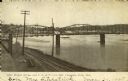
| Date: | 1910 |
|---|---|
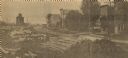
| Description: | Photographic postcard of elevated view of the back of mills lining the bridge. Coal kilns are below the hand-drawn arrow at top right. "Sawmills, gristmill... |
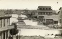
| Date: | 1910 |
|---|---|
| Description: | Elevated view looking east and upstream from the shoreline towards the wide Chippewa River. The water level is nearly up to the railroad tracks in the fore... |

| Date: | 1900 |
|---|---|
| Description: | This photostat map shows private claim owners, natural meadows, roads, saw and grist mills, and Fort Howard. The upper right corner includes annotations an... |

| Date: | 12 1912 |
|---|---|
| Description: | Sanborn Map of Sun Prairie. The map highlights the public and parochial schools, the exhange, and church buildings, etc. |
| Date: | |
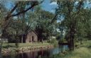
|---|---|
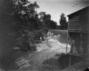
| Description: | Ektachrome postcard of the blacksmith shop next to a stream. Text on reverse reads: "The Blacksmith Shop was Sylvanus Wade's first venture in Greenbush.... |
If you didn't find the material you searched for, our Library Reference Staff can help.
Call our reference desk at 608-264-6535 or email us at: