 Filter: Subject of industry
Filter: Subject of indian reservations
Filter: Subject of industry
Filter: Subject of indian reservations
| Date: | |
|---|---|
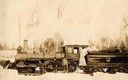
| Description: | Three men stand in the snow in front of the Wisconsin & Northern Railroad engine #2 (the second locomotive with this number) in the woods on the Menominee ... |

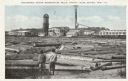
| Date: | 1910 |
|---|---|
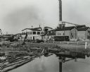
| Description: | Sawmill on a Menominee Indian reservation, with logs floating in the water in the foreground. Caption reads: "Menominee Indian Mills." |
| Date: | |
|---|---|
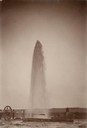
| Description: | Water gushes 18 feet in the air from a 6-inch pipe at the Lower Brule Agency. A man stands behind the pipe on the right. |
| Date: | |
|---|---|
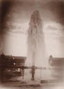
| Description: | Water gushes 60 feet in the air from a 4-inch pipe at the Lower Brule Agency. Two men stand on the left near pumping machinery. |
| Date: | |
|---|---|
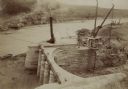
| Description: | The head gate at the Big Horn Ditch on the Crow Reservation in northeast Wyoming. Men are working with cranes near a tent with a chimney spewing out smoke. |
| Date: | 1950 |
|---|---|
| Description: | A sawmill run on the Menominee Indian Reservation. |

| Date: | |
|---|---|
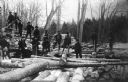
| Description: | Indians (Native Americans) unloading logs at the sawmill on the Menominee Reservation. |
| Date: | 1909 |
|---|---|
| Description: | A group of Native American Indian loggers pose on piles of logs at the Courtes Oreilles Reservation. |

| Date: | 1936 |
|---|---|
| Description: | Loading a large white pine log cut on the Menominee Indian Reservation onto a truck. The log was hauled to the Wisconsin State Fair for a display about the... |
| Date: | 03 1938 |
|---|---|
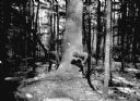
| Description: | A large white pine being felled on the Menominee Indian Reservation. This photograph was taken to illustrate the tribe's selective logging practices. |
| Date: | 1936 |
|---|---|
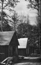
| Description: | Exterior view of a logging camp on the Menominee Indian Reservation. The three buildings are surrounded by forest. |
| Date: | |
|---|---|
| Description: | Mill on the Menominee Indian Reservation between Antigo and Shawano. Two young boys are standing in the foreground on the shoreline looking at logs ready f... |

| Date: | 1847 |
|---|---|
| Description: | A hand-colored map that shows the area south and east of the Wisconsin and Fox Rivers, as well as a few landmarks just north of that area. The township gri... |

| Date: | 1855 |
|---|---|
| Description: | This map shows the township survey grid and identifies counties, named towns, rivers, lakes, railroads, plank roads, mines, and the Menomonee Reservation. ... |

| Date: | 1872 |
|---|---|
| Description: | This map, which includes eastern Iowa, northern Illinois and a portion of Michigan's Upper peninsula, shows the township survey grid and identifies countie... |

| Date: | 1896 |
|---|---|
| Description: | A map of Iron County, Wisconsin, shows vacant Wisconsin Central Rail Road lands, settlers houses, land sold by Wisconsin Central R.R., schools, churches, s... |

| Date: | 1898 |
|---|---|
| Description: | A map of Iron County, Wisconsin, shows vacant Wisconsin Central Rail Road lands, settlers houses, land sold by Wisconsin Central R.R., schools, churches, s... |

| Date: | |
|---|---|
| Description: | Map of northern Iron County, Wisconsin, shows town sections and railroads in the towns of Saxon, Kimball, and Gurney. It also includes the area of the La P... |

| Date: | 1896 |
|---|---|
| Description: | This 1898 map shows the township and range system, sections, cities and villages, railroads, roads, vacant land and land sold by the Wisconsin Central Rail... |

| Date: | 1900 |
|---|---|
| Description: | This 1900 map shows the township and range system, sections, cities and villages, railroads, roads, vacant land and land sold by the Wisconsin Central Rail... |
If you didn't find the material you searched for, our Library Reference Staff can help.
Call our reference desk at 608-264-6535 or email us at: