 Filter: Subject of land use, rural
Filter: Subject of harbors
Filter: Subject of land use, rural
Filter: Subject of harbors
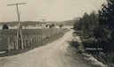
| Date: | 1905 |
|---|---|
| Description: | A lane in Ephraim with power lines lining the road. There is a body of water in the distance with houses on the far shoreline. |

| Date: | 1715 |
|---|---|
| Description: | A map of the countries and islands surrounding the Gulf of Mexico. The hand-colored borders separate the territories of England, France, Spain, and Holland... |
If you didn't find the material you searched for, our Library Reference Staff can help.
Call our reference desk at 608-264-6535 or email us at: