Filter: Subject of land use, rural
Filter: Subject of intellectual life
Filter: Subject of land use, rural
Filter: Subject of intellectual life
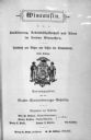
| Date: | 1880 |
|---|---|
| Description: | Cover of a pamphlet, printed in German, advertising land for sale in Wisconsin. |

| Date: | 1908 |
|---|---|
| Description: | Five volumes of the Crown Collection of American Maps, plus an index, showing the spines of these books. |
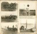
| Date: | |
|---|---|
| Description: | A scrapbook page containing five photographs of John R. Commons and farm labor. The handwriting in the center reads: "Dale Farm with AL and Windy." Caption... |

| Date: | 1780 |
|---|---|
| Description: | Plan for layout of 150,00 acres which make up Clark's Illinois Grant. |
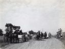
| Date: | 1913 |
|---|---|
| Description: | Mr. J.E. Waggoner, International Harvester Company Agricultural Extension Dept. employee, delivering roadside alfalfa lecture to a crowd of farmers arrivin... |
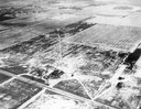
| Date: | 01 1934 |
|---|---|
| Description: | An aerial view of the Oshkosh Airport about three years after Steve Wittman became the manager. The field was established in 1928 by Oshkosh Airport, Inc.... |

| Date: | 1942 |
|---|---|
| Description: | Aerial view of Oscar Mayer & Company, 910 Mayer Avenue at Packers Avenue. Shows stock yards, railroad cars and automobile parking lot. Also shows C.E. & P.... |

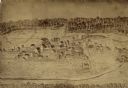
| Date: | 1875 |
|---|---|
| Description: | Aerial view of Alma along Mississippi River, with bluffs along the horizon. |

| Date: | 1850 |
|---|---|
| Description: | Lithograph of a map drawn to indicate a mine on land owned by Mineral Point Mining Co. in the lead region of southwestern Wisconsin. |

| Date: | 1955 |
|---|---|
| Description: | Aerial view of town, with the Baraboo River. |

| Date: | 1945 |
|---|---|
| Description: | Aerial view of the "powder storage area" of the Badger Ordnance Plant. |

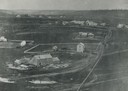
| Date: | 1955 |
|---|---|
| Description: | Aerial view of Cross Plains, with countryside surrounding and hills on the horizon. |

| Date: | 1956 |
|---|---|
| Description: | Aerial view of the new Madison television facility, WISC-TV (Channel 3), showing the transmitting tower in construction. The location is to the southwest,... |

| Date: | |
|---|---|
| Description: | Aerial view of a train crossing the East River in a rural community south of Green Bay. Some buildings are visible to the right and the background of the i... |
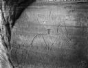
| Date: | |
|---|---|
| Description: | Thunderbird petroglyphs carved on rock face at Twin Bluffs. |

| Date: | 1957 |
|---|---|
| Description: | Aerial view of Yellowstone Lake and surrounding countryside. |
If you didn't find the material you searched for, our Library Reference Staff can help.
Call our reference desk at 608-264-6535 or email us at: