 Filter: Subject of land use, rural
Filter: Subject of law
Filter: Subject of land use, rural
Filter: Subject of law
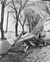
| Date: | 02 21 1947 |
|---|---|
| Description: | After hooking a wing into a huge tree, an airplane piloted by Carl Anderson crashed onto a town road in Fitchburg near the Sam McGaw farm. The impact tore ... |

| Date: | 08 07 1947 |
|---|---|
| Description: | Abandoned army shooting range at Truax Field, with Police Officer Lester Shore in the lower right foreground. |
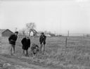
| Date: | |
|---|---|
| Description: | View of a chain gang from the front window of a car. |
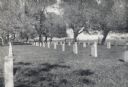
| Date: | 1955 |
|---|---|
| Description: | Cemetery surrounded by trees. There is a fence and field in the distance. |

| Date: | 11 28 1949 |
|---|---|
| Description: | County Traffic officers, E. W. Kelzenberg and Emil Schmale, and Evan Chambers of the state crime laboratory looking at the death scene of Bernice Johnson. ... |
| Date: | 11 28 1949 |
|---|---|
| Description: | County officers and state crime lab officials searching for clues in the pasture near Fitch Hatchery road, where Bernice Johnston was beaten and abandoned.... |

| Date: | 1910 |
|---|---|
| Description: | Six Ho-Chunk men lined up for a group portrait at the powwow grounds. The men with sticks in their hands are members of the Bear Clan, who act as police fo... |

| Date: | 1955 |
|---|---|
| Description: | State patrol officers line up beside their patrol cars at Old District 1 State Patrol Field Headquarters on Highway 12. They appear to be receiving instruc... |

| Date: | 1920 |
|---|---|
| Description: | A man standing in the cook house doorway at a convict camp comprised of several tents and a iron cage on wheels. |

| Date: | 1961 |
|---|---|
| Description: | Evacuation route out of Milwaukee. View from the side of the road looking downhill towards the rear of a Wisconsin State Patrol cruiser parked on the right... |

| Date: | 1770 |
|---|---|
| Description: | The south west sheet of a four sheet map of Virginia, showing the counties, mountains, rivers, court houses, a few cities, and mills. A few Plantations ar... |

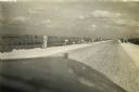
| Date: | |
|---|---|
| Description: | View over tall plants towards a small building with windows and a door, as well as a smaller outbuilding on the right. |
If you didn't find the material you searched for, our Library Reference Staff can help.
Call our reference desk at 608-264-6535 or email us at: