 Filter: Subject of land use, urban
Filter: Subject of bays
Filter: Subject of land use, urban
Filter: Subject of bays
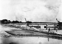
| Date: | 1907 |
|---|---|
| Description: | A steam-powered dredge anchored in Monona Bay is filling in Brittingham Park. |
| Date: | 08 2013 |
|---|---|
| Description: | View from shoreline of natural plants and trees towards the Madison skyline from across Monona Bay. A line of high-rise buildings frame the Wisconsin State... |

| Date: | 01 2014 |
|---|---|
| Description: | View from shoreline on a sunny day of snow-covered, frozen Monona Bay. People in the distance are standing or sitting near ice fishing holes and ice fishin... |

| Date: | 1759 |
|---|---|
| Description: | Map of New Orleans at the start of the French & Indian War, including two inset maps entitled "The Course of the Mississipi River from Bayagoulas to the Se... |

| Date: | 1769 |
|---|---|
| Description: | Map of New Orleans at the start of the French & Indian War, including two inset maps of the Mississippi River Delta and Fort la Balise. It shows streets, r... |

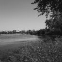
| Date: | 08 20 2014 |
|---|---|
| Description: | View of Monona Bay. Grass and trees are growing along the shoreline. Downtown Madison, including the Wisconsin State Capitol, is on the opposite shoreline. |
If you didn't find the material you searched for, our Library Reference Staff can help.
Call our reference desk at 608-264-6535 or email us at: