Filter: Subject of land use, urban
Filter: Subject of farms
Filter: Subject of land use, urban
Filter: Subject of farms

| Date: | 1955 |
|---|---|
| Description: | Aerial view of Cross Plains, with countryside surrounding and hills on the horizon. |

| Date: | 11 1928 |
|---|---|
| Description: | Aerial view of Verona including businesses, houses, and the surrounding farm land. |

| Date: | 10 1928 |
|---|---|
| Description: | Aerial view of Sun Prairie, including the central business district, residences, and the surrounding countryside stretching to the horizon. |

| Date: | 11 1928 |
|---|---|
| Description: | Aerial view residential areas of Windsor and the surrounding countryside. |

| Date: | 11 1928 |
|---|---|
| Description: | Aerial view of Black Earth residential area and the surrounding countryside. |

| Date: | 11 1928 |
|---|---|
| Description: | Aerial view of Cross Plains, including residences and the surrounding countryside. |

| Date: | 1956 |
|---|---|
| Description: | Aerial view over University Avenue of the University of Wisconsin-Madison campus, including University farm in the upper middle. The shoreline of Lake Mend... |

| Date: | |
|---|---|
| Description: | Elevated view of Mount Horeb from the water tower. Homes and commercial structures dominate the left side, while farmland and newly-developed tracts are to... |
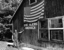
| Date: | 2004 |
|---|---|
| Description: | Marvin Giese shows his feelings to his country with this display on a barn wall. |
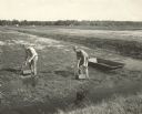
| Date: | |
|---|---|
| Description: | Two men harvesting cranberries with cranberry rakes in Wisconsin marshes. There is a barge near them on the right. |
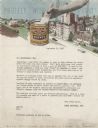
| Date: | |
|---|---|
| Description: | Letterhead of Patek Brothers, Inc., of Milwaukee, Wisconsin, a paint company, with a halftone image of a hand dipping a brush into a can of Patek paint, el... |

| Date: | 1973 |
|---|---|
| Description: | This map is 1 of 7 and includes a location map and township diagram in the margins. The map includes a key of land type: Residential (yellow), Commercial (... |

| Date: | 1973 |
|---|---|
| Description: | This map is 2 of 7 and includes a location map and township diagram in the bottom margin. The map includes a key of land type: Residential (yellow), Commer... |

| Date: | 1973 |
|---|---|
| Description: | This map is 3 of 7 and includes a location map and township diagram in the margins. The map includes a key of land type: Residential (yellow), Commercial (... |

| Date: | 1973 |
|---|---|
| Description: | This map is 4 of 7 and includes a location map and township diagram in the left margin. The map includes a key of land type: Residential (yellow), Commerci... |

| Date: | 1913 |
|---|---|
| Description: | This photocopy map shows plots with owners' names, land use both commercial and agricultural, and lot outlines on University land. Lake Mendota is labeled ... |

| Date: | 1776 |
|---|---|
| Description: | Fairly detailed map of New York City and parts of Long Island. It shows streets, roads, wharves, ferries, ship yards, Fort George and the battery, public b... |
If you didn't find the material you searched for, our Library Reference Staff can help.
Call our reference desk at 608-264-6535 or email us at: