 Filter: Subject of land use, urban
Filter: Subject of land use, rural
Filter: Subject of land use, urban
Filter: Subject of land use, rural

| Date: | 1955 |
|---|---|
| Description: | Aerial view of town, with the Baraboo River. |

| Date: | 1955 |
|---|---|
| Description: | Aerial view of Cross Plains, with countryside surrounding and hills on the horizon. |
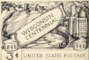
| Date: | |
|---|---|
| Description: | Design for Wisconsin Centennial 3 cent postage stamp featuring a dairy and agriculture theme. |

| Date: | 11 1928 |
|---|---|
| Description: | Aerial view of Verona including businesses, houses, and the surrounding farm land. |

| Date: | 10 1928 |
|---|---|
| Description: | Aerial view of Sun Prairie, including the central business district, residences, and the surrounding countryside stretching to the horizon. |

| Date: | 11 1928 |
|---|---|
| Description: | Aerial view of Stoughton, including the central business district, residential areas, the Yahara River, and the surrounding countryside. |

| Date: | 11 1928 |
|---|---|
| Description: | Aerial view residential areas of Windsor and the surrounding countryside. |

| Date: | 11 1928 |
|---|---|
| Description: | Aerial view of Black Earth residential area and the surrounding countryside. |

| Date: | 11 1928 |
|---|---|
| Description: | Aerial view of Cross Plains, including residences and the surrounding countryside. |

| Date: | |
|---|---|
| Description: | Elevated view of Mount Horeb from the water tower. Homes and commercial structures dominate the left side, while farmland and newly-developed tracts are to... |

| Date: | 1940 |
|---|---|
| Description: | Cover of an advertising brochure for International D-2 and D-3 trucks. Original caption reads: "International Models D-2 and D-3 for economical light deliv... |

| Date: | 1935 |
|---|---|
| Description: | This map shows in different colors virgin timberland, second growth timber, pasture belt, crop-pasture belt, intensive crop-pasture belt, intensive pasture... |

| Date: | 1938 |
|---|---|
| Description: | This map shows "regional designation problem areas" and "nature of problem or solution." The left margin has a key showing the problem areas. The right mar... |
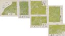
| Date: | 1975 |
|---|---|
| Description: | This series of six maps identifies land use in Taylor, Price, Rusk, Sawyer, Washburn, and Burnett counties based on data from 1966 through 1975. Each map i... |

| An intimate look at family, architecture, interiors and fashion in Victorian Wisconsin between 1885 and 1900 |
|---|
| Learn about the lives of upper-middle class Wisconsinites in the Victorian period between 1885 and 1900. |
| Ever wonder why beer is so popular in Wisconsin? Wisconsin history is full of breweries and beer. |

| Date: | 1921 |
|---|---|
| Description: | Elevated view of Woodstock, with dwellings, farm buildings and a church. Pastures and fields surround the town. |

| Date: | 1973 |
|---|---|
| Description: | This map shows the uses of land in St. Croix County. Uses are indicated by colored dots. Residential(Yellow), Commercial(Red), Industrial(Grey), Parks and ... |

| Date: | 1910 |
|---|---|
| Description: | This map shows the Soo Line railroad and Arpin Hardwood Lumber Company lands in red. The top margin of the map reads: "Wisconsin, the safest state in the U... |
If you didn't find the material you searched for, our Library Reference Staff can help.
Call our reference desk at 608-264-6535 or email us at:
