 Filter: Subject of land use, urban
Filter: Subject of maps
Filter: Subject of land use, urban
Filter: Subject of maps

| Date: | 1917 |
|---|---|
| Description: | The Lake Forest community plan, a model community that was planned for the site where the University of Wisconsin Arboretum now stands. |
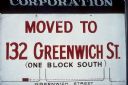
| Date: | 1969 |
|---|---|
| Description: | A sign reads that a business has "Moved to 132 Greenwich St. (one block south)." Along with the written description, there is a small map to show where the... |

| Date: | 1890 |
|---|---|
| Description: | Letterhead for Moulton, Moran & Co. The logo shows North America and depicts Superior as the center of a hub with spokes going to Russia, to China and Japa... |

| Date: | 1910 |
|---|---|
| Description: | This map shows the Soo Line railroad and Arpin Hardwood Lumber Company lands in red. The top margin of the map reads: "Wisconsin, the safest state in the U... |

| Date: | 1913 |
|---|---|
| Description: | This photocopy map shows plots with owners' names, land use both commercial and agricultural, and lot outlines on University land. Lake Mendota is labeled ... |

| Date: | 1941 |
|---|---|
| Description: | This map shows heavy and light industry, residences, and business districts as well as streets and Mill Pond. The front and back of the map include extensi... |

| Date: | 1715 |
|---|---|
| Description: | A map of the countries and islands surrounding the Gulf of Mexico. The hand-colored borders separate the territories of England, France, Spain, and Holland... |

| Date: | 11 09 1960 |
|---|---|
| Description: | Chet Bible, owner of Madison Mobile Homes along the Madison Beltline, points to his property on a map at a hearing held in the City-County building by the ... |

| Date: | 11 09 1960 |
|---|---|
| Description: | A display to illustrate proposed improvements to the Madison Beltline highway at a hearing in the City-County Building by the State Highway Commission. |
If you didn't find the material you searched for, our Library Reference Staff can help.
Call our reference desk at 608-264-6535 or email us at: