 Filter: Subject of land use, urban
Filter: Subject of planning
Filter: Subject of land use, urban
Filter: Subject of planning
| Date: | 1915 |
|---|---|
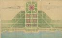
| Description: | Drawings and blueprints of the arrangement and planting design of a small town. |

| Date: | 1969 |
|---|---|
| Description: | A construction worker wearing a yellow hardhat looks up at the bottom portion of the World Trade Center. |

| Date: | 1917 |
|---|---|
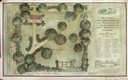
| Description: | The Lake Forest community plan, a model community that was planned for the site where the University of Wisconsin Arboretum now stands. |
| Date: | 1930 |
|---|---|
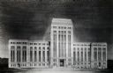
| Description: | A chalk rendering of the proposed State Office Building by State Architect, Arthur Peabody. The Wisconsin State Capitol is visible in the background. |
| Date: | 1929 |
|---|---|
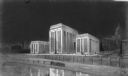
| Description: | A drawing of a State Office Building as originally proposed. |

| Date: | 1905 |
|---|---|
| Description: | A drawing by State Architect, Arthur Peabody, depicting the proposed State Street facade of the University Club building. |
| Date: | 1916 |
|---|---|
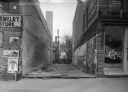
| Description: | A building site at 11 West Main Street, next to Gamm's Jewelry Store and Cop's Cafe. Power lines are in the alley in the background. |
| Date: | 1925 |
|---|---|
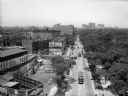
| Description: | Elevated view north along Clark Street with pedestrians, street cars, trucks and automobiles. Lincoln Park is on the right; the Belden Stratford Hotel is o... |
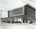
| Date: | 11 05 1924 |
|---|---|
| Description: | Automobile and trucks are parked alongside the International Harvester branch building in Albany. A sign painted on the upper side of the building reads, "... |
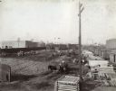
| Date: | 1900 |
|---|---|
| Description: | Men use teams of horses to excavate a lot to be used as the site for the future McCormick Twine Mill. |

| Date: | 1792 |
|---|---|
| Description: | Map of Washington D.C. Labeled on the map are all the main streets, the site of the Capitol and the President's House. The map also shows the relationship ... |
| Date: | 07 1939 |
|---|---|
| Description: | An architectural rendering of a proposed lakefront development plan. |
If you didn't find the material you searched for, our Library Reference Staff can help.
Call our reference desk at 608-264-6535 or email us at: