 Filter: Subject of land use, urban
Filter: Subject of rivers
Filter: Subject of land use, urban
Filter: Subject of rivers
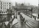
| Date: | 1904 |
|---|---|
| Description: | Elevated view of wagons hauling coal from the Milwaukee Western Fuel Company holding up street car traffic on a busy Milwaukee street. |
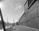
| Date: | |
|---|---|
| Description: | Elevated view of Milwaukee River from Walker's Point Bridge. |
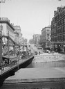
| Date: | |
|---|---|
| Description: | View up Wisconsin Avenue towards a bridge with pedestrian and horse-drawn vehicle traffic. Buildings along a street are in the distance. |
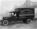
| Date: | 07 05 1927 |
|---|---|
| Description: | Driver in an International delivery truck parked along the waterfront with the Queensboro Bridge in the background. The truck was owned by Joseph Victori &... |

| Date: | 1854 |
|---|---|
| Description: | Bird's-eye view of Milwaukee looking east toward Lake Michigan from a bluff, long since graded into a slope, at about 6th Street between Wisconsin Avenue a... |

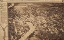
| Date: | 1937 |
|---|---|
| Description: | Bird's-eye view of Milwaukee in 1853 details building features and city layout from southwest. Important buildings are numbered in a silhouette drawing bel... |

| Date: | 1892 |
|---|---|
| Description: | Bird's-eye view of Chicago, with ships in the Lake Michigan harbor. |
| Date: | 09 14 1963 |
|---|---|
| Description: | The Marathon Paper Corporation plant along the historic Fox River canal. |

| Date: | 1892 |
|---|---|
| Description: | Bird's-eye view of the Columbian Exposition pavilions from the vantage point of Lake Michigan. Included is an inset of the Union Passenger Station (now Uni... |

| Date: | 1930 |
|---|---|
| Description: | Aerial view of the city and the river. |

| Date: | 1955 |
|---|---|
| Description: | Aerial view of town, with the Baraboo River. |
| Date: | 1923 |
|---|---|
| Description: | Aerial view of town with river. The clipping from a newspaper has a description titled: "Seeing Wisconsin From an Airplane". |

| Date: | 1965 |
|---|---|
| Description: | Aerial view of downtown Big Falls and the Little Wolf River. The Little Wolf River is at lower right. |

| Date: | 1867 |
|---|---|
| Description: | Drawn map showing planned development of Cornell, including a couple of schools, Oakwood cemetery, the public square, and several bridges and dams. |
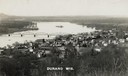
| Date: | 1910 |
|---|---|
| Description: | Elevated view of Durand from a high vantage point, looking towards the river. A bridge spans the river, and in the foreground just below the hill is a chur... |

| Date: | 1930 |
|---|---|
| Description: | Aerial view of city, with Eau Claire River is in the foreground with Milwaukee railroad bridge at left. Gillette Rubber Co. plant is in center with Omaha r... |

| Date: | 1956 |
|---|---|
| Description: | Aerial view looking northeast from a point over the east end of Middleton, showing the west end of Lake Mendota (right mid-ground). Fox Bluff juts into the... |
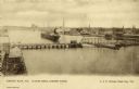
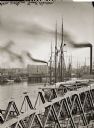
| Date: | 1900 |
|---|---|
| Description: | Looking North. Harbor with boats, bridge, and buildings. |
If you didn't find the material you searched for, our Library Reference Staff can help.
Call our reference desk at 608-264-6535 or email us at:

