 Filter: Subject of lighthouses
Filter: Subject of botany
Filter: Subject of roads
Filter: Subject of lighthouses
Filter: Subject of botany
Filter: Subject of roads

| Date: | 1856 |
|---|---|
| Description: | View looking west from Lake Michigan with several steam ships and sailing vessels in harbor. There is a lighthouse to left of center, along shoreline. |

| Date: | 1856 |
|---|---|
| Description: | View of Manitowoc from the north side. |
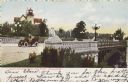
| Date: | 1916 |
|---|---|
| Description: | South entrance to park. The bridge has stone lion sculptures on each of its corners, as well as ornate street lamps. A lighthouse and attached buildings ar... |
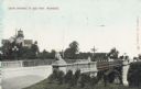
| Date: | 1905 |
|---|---|
| Description: | South entrance; an open car with two people is crossing the bridge. Stone lions flank the bridge on each corner. A lighthouse is in the background. Caption... |

| Date: | 1909 |
|---|---|
| Description: | View across lawn toward the bridge on the right. The lighthouse is in the background, as well as several other buildings in the distance. The bridge is fla... |
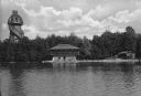
| Date: | |
|---|---|
| Description: | View across water towards the Mayor's summer home as seen from across Pine Lake. Children and adults are standing in front of the two-story dwelling. To th... |

| Date: | 1916 |
|---|---|
| Description: | This Wisconsin Conservation Commission map from 1916 shows Peninsula State Park in the Town of Gibraltar, Door County, Wisconsin. Depicted are open and pla... |

| Date: | 1916 |
|---|---|
| Description: | This version of a 1916 Wisconsin Conservation Commission map shows Peninsula State Park in the Town of Gibraltar, Door County, Wisconsin. Depicted are open... |

| Date: | 1960 |
|---|---|
| Description: | This mid-20th century tourist brochure for Bayfield County, Wisconsin, includes a map of the county showing towns, cities and villages, highways and roads,... |

| Date: | 1967 |
|---|---|
| Description: | This tourist brochure for Bayfield County, Wisconsin, from 1967 includes a map of the county showing towns, cities and villages, highways and roads, railro... |

| Date: | 1915 |
|---|---|
| Description: | This map of Door County, Wisconsin, from the early 20th century shows roads, schools, churches, creameries and cheese factories, orchards, docks, quarries,... |
| Date: | 1962 |
|---|---|
| Description: | Color postcard of a small, tower-like building on the side of a road. |

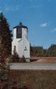
| Date: | 1962 |
|---|---|
| Description: | Color photograph of a range light built in 1870 to guide ships into the harbor at The Ridges Sanctuary, north of Bailey's Harbor, Door County. The Ridges S... |

| Date: | 1940 |
|---|---|
| Description: | A log gate and log-framed sign mark the entrance to the Twin River (Rawley) Point lighthouse. The keeper's house is next to the light and has a turret and ... |
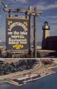
| Date: | 1973 |
|---|---|
| Description: | Text on sign reads: "Lighthouse on the Lake, Motel, Restaurant, Indoor Pool." On reverse: "Lighthouse Inn on the Lake. Highway 42, 1515 Memorial Drive, Two... |
If you didn't find the material you searched for, our Library Reference Staff can help.
Call our reference desk at 608-264-6535 or email us at: