 Filter: Subject of lighthouses
Filter: Subject of harbors
Filter: Subject of transportation
Filter: Subject of lighthouses
Filter: Subject of harbors
Filter: Subject of transportation
| Date: | |
|---|---|
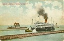
| Description: | The screw passenger excursion vessel, "Christopher Columbus," being towed into the Milwaukee harbor past a breakwater. Milwaukee North Pier Inner Light in ... |

| Date: | 01 04 1862 |
|---|---|
| Description: | Engraving of the city of Superior and Lake Superior, also depicting railroad piers, Minnesota Point, and the steamboat "Star". The engraving appears on a l... |

| Date: | 1930 |
|---|---|
| Description: | Caption reads: "'The Old Standby' First Lighthouse Built at the Head of Lake Superior—Superior Entry — 1854 Keepers, Com. Saxton and Samuel Palmer." |
| Date: | 1910 |
|---|---|
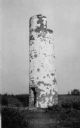
| Description: | View of the remnants of the Minnesota Point Lighthouse. Faint caption at bottom reads: "Lighthouse". |
| Date: | |
|---|---|
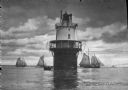
| Description: | View across water toward the Spring Point Lighthouse, established in 1897 and automated in 1934. There is a small boat near the base of the lighthouse, and... |
| Date: | |
|---|---|
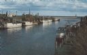
| Description: | Color photographic postcard of the fisherman's dock taken from the harbor walkway. White boats are moored on either side of the Ahnapee River as it flows i... |

| Date: | 1880 |
|---|---|
| Description: | Map of Wisconsin including the eastern portions on Minnesota, Iowa, northern Illinois, and the western most portion of Michigan’s Upper Peninsula, showing ... |

| Date: | 1916 |
|---|---|
| Description: | This Wisconsin Conservation Commission map from 1916 shows Peninsula State Park in the Town of Gibraltar, Door County, Wisconsin. Depicted are open and pla... |

| Date: | 1916 |
|---|---|
| Description: | This version of a 1916 Wisconsin Conservation Commission map shows Peninsula State Park in the Town of Gibraltar, Door County, Wisconsin. Depicted are open... |

| Date: | 1871 |
|---|---|
| Description: | Engraved view of Kenosha harbor. A group of men fish from a pier in the foreground while several boats float through the harbor. A tug is pulling a large s... |

| Date: | 1911 |
|---|---|
| Description: | This map of Duluth and Superior shows street car routes, railroads, ferries, some points of interest, and lighthouses. The bottom left of the map reads: "C... |

| Date: | 1941 |
|---|---|
| Description: | Elevated view of Sturgeon Bay in 1900. Sturgeon Bay Bridge spans the bay and several boats are on the water. A lighthouse sits on a small island in the bay... |

| Date: | 01 08 1958 |
|---|---|
| Description: | Elevated view from 8th Street Bridge over the Manitowoc River towards Lake Michigan. There is a lighthouse in the distance. Ice is floating on the water. A... |

| Date: | 01 07 1958 |
|---|---|
| Description: | View from the Second Street bridge over the icy Ahnapee River towards Lake Michigan. A lighthouse is at the end of a jetty in the far background. Boats are... |
| Date: | 07 27 1960 |
|---|---|
| Description: | View from shoreline at Port Washington south of two ramps within a breakwater. There is a lighthouse in the background. Boats are along a pier on the right... |

| Date: | 12 10 1957 |
|---|---|
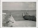
| Description: | View of harbor with pilings in the right foreground. There is a lighthouse on breakwaters in the distance. |

| Date: | |
|---|---|
| Description: | Aerial view of harbor. In the foreground is a lighthouse and breakwaters. Bridges cross the harbor, and there are factory and industrial buildings near the... |

| Date: | 07 19 1854 |
|---|---|
| Description: | This map shows the shore in 1844, 1850, and 1852, the length of and proposed additions to the pier. Relief is shown by hachures and depths are shown by sou... |

| Date: | 1905 |
|---|---|
| Description: | This map shows railroads, towns, lights, lights to be established, fog signals, light-vessels, lighted buoys, light-house depots, and light-house reservati... |

| Date: | 04 1926 |
|---|---|
| Description: | This blueprint mostly shows various numbers within the canal and bay. Lake Michigan and Harobor of Refuge are shown along the far right side. Near the harb... |
If you didn't find the material you searched for, our Library Reference Staff can help.
Call our reference desk at 608-264-6535 or email us at: