 Filter: Subject of lighthouses
Filter: Subject of lakes
Filter: Creator Name of Unknown
Filter: Subject of lighthouses
Filter: Subject of lakes
Filter: Creator Name of Unknown
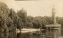
| Date: | 1910 |
|---|---|
| Description: | View of the north shore of Delavan Lake with a lighthouse in the background. Also known as "Red Top" and "L.P. Sutter's." Caption reads: North Shore, Delav... |
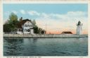
| Date: | 1920 |
|---|---|
| Description: | View across water toward the lighthouse. Caption reads: "Grassy Island Lighthouse, Green Bay, Wis." |
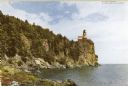
| Date: | |
|---|---|
| Description: | View along rocky shoreline toward the lighthouse. Caption reads: "Split Rock Lighthouse on north shore of Lake Superior." |

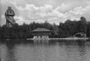
| Date: | 1937 |
|---|---|
| Description: | Lighthouse built by State Senator William Bray of Oshkosh, on a point where the Fox River empties into Lake Winnebago. |
| Date: | |
|---|---|
| Description: | View across water towards the Mayor's summer home as seen from across Pine Lake. Children and adults are standing in front of the two-story dwelling. To th... |

| Date: | 1946 |
|---|---|
| Description: | Map of Kewaunee County, Wisconsin, shows towns, cities and villages, roads and highways, railroads, schools, lighthouses, place names, town divisions, comm... |

| Date: | 1960 |
|---|---|
| Description: | This mid-20th century tourist brochure for Bayfield County, Wisconsin, includes a map of the county showing towns, cities and villages, highways and roads,... |

| Date: | 1967 |
|---|---|
| Description: | This tourist brochure for Bayfield County, Wisconsin, from 1967 includes a map of the county showing towns, cities and villages, highways and roads, railro... |

| Date: | 1905 |
|---|---|
| Description: | This map shows railroads, towns, lights, lights to be established, fog signals, light-vessels, lighted buoys, light-house depots, and light-house reservati... |

| Date: | 1905 |
|---|---|
| Description: | This map shows railroads, towns, lights, lights to be established, fog signals, light-vessels, lighted buoys, light-house depots, and light-house reservati... |

| Date: | 1905 |
|---|---|
| Description: | This map shows railroads, towns, lights, lights to be established, fog signals, light-vessels, lighted buoys, light-house depots, and light-house reservati... |

| Date: | 1908 |
|---|---|
| Description: | This map shows railroads, towns, lights, lights to be established, fog signals, light-vessels, lighted buoys, light-house depots, and light-house reservati... |

| Date: | 1857 |
|---|---|
| Description: | This map shows lot and block numbers, streets, railroad depots, locks, bridges, dams, canals, U.S. light house, college grounds, a steam boat landing, and ... |
If you didn't find the material you searched for, our Library Reference Staff can help.
Call our reference desk at 608-264-6535 or email us at: