 Filter: Subject of lighthouses
Filter: Subject of lakes
Filter: Subject of lighthouses
Filter: Subject of lakes

| Date: | 1896 |
|---|---|
| Description: | This 1896 map of Racine and Kenosha counties, Wisconsin, shows the township and range grid, towns, sections, cities, villages and post offices, roads, rail... |
| Date: | |
|---|---|
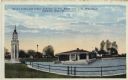
| Description: | Hand-colored postcard view of the lighthouse and boathouse at Bray's Point. Caption reads: "Bray's Point and Light, Junction of Fox River with Lake Winneba... |

| Date: | 1960 |
|---|---|
| Description: | This mid-20th century tourist brochure for Bayfield County, Wisconsin, includes a map of the county showing towns, cities and villages, highways and roads,... |

| Date: | 1967 |
|---|---|
| Description: | This tourist brochure for Bayfield County, Wisconsin, from 1967 includes a map of the county showing towns, cities and villages, highways and roads, railro... |

| Date: | 1915 |
|---|---|
| Description: | This map of Door County, Wisconsin, from the early 20th century shows roads, schools, churches, creameries and cheese factories, orchards, docks, quarries,... |

| Date: | 1848 |
|---|---|
| Description: | This map shows lighthouses on part of Lake Superior, Green Bay, Lake Michigan, Lake Huron, Lake St. Clair, Lake Erie, Lake Ontario, the St. Lawrence River,... |

| Date: | 1905 |
|---|---|
| Description: | This map shows railroads, towns, lights, lights to be established, fog signals, light-vessels, lighted buoys, light-house depots, and light-house reservati... |

| Date: | 1905 |
|---|---|
| Description: | This map shows railroads, towns, lights, lights to be established, fog signals, light-vessels, lighted buoys, light-house depots, and light-house reservati... |

| Date: | 1905 |
|---|---|
| Description: | This map shows railroads, towns, lights, lights to be established, fog signals, light-vessels, lighted buoys, light-house depots, and light-house reservati... |

| Date: | 1908 |
|---|---|
| Description: | This map shows railroads, towns, lights, lights to be established, fog signals, light-vessels, lighted buoys, light-house depots, and light-house reservati... |

| Date: | 1857 |
|---|---|
| Description: | This map shows lot and block numbers, streets, railroad depots, locks, bridges, dams, canals, U.S. light house, college grounds, a steam boat landing, and ... |

| Date: | 1938 |
|---|---|
| Description: | This map shows roads, parks, golf courses, airports, beaches, docks and harbors, lighthouses, and buoys within Winnebago County and parts of Waushara, Calu... |
| Date: | |
|---|---|
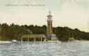
| Description: | Color postcard view across water towards L.P. Sutter's tower along the shore of Delavan Lake. Caption reads: "Along the Shore, L.P. Sutter's, Delavan Lake,... |
| Date: | 1963 |
|---|---|
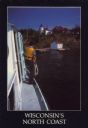
| Description: | Text on front reads: "Wisconsin's North Coast." A man is standing on the side deck of a boat, and in the distance is the Raspberry Island Lighthouse with a... |

| Date: | 03 23 1915 |
|---|---|
| Description: | Text on front reads: "Steamship William E. Corey, entering Duluth and Superior Harbor, Wis." A steamship entering the harbor under the Aerial Lift Bridge, ... |
If you didn't find the material you searched for, our Library Reference Staff can help.
Call our reference desk at 608-264-6535 or email us at: