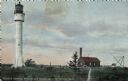
 Filter: Subject of lighthouses
Filter: Subject of land
Filter: Subject of transportation
Filter: Subject of lighthouses
Filter: Subject of land
Filter: Subject of transportation

| Date: | 1856 |
|---|---|
| Description: | View looking west from Lake Michigan with several steam ships and sailing vessels in harbor. There is a lighthouse to left of center, along shoreline. |

| Date: | 07 04 1931 |
|---|---|
| Description: | Inside of Saturday dinner menu for the "North American." Includes drawings of Niagara Falls, New York, Old Fort Mackinac Island, Michigan, Michigan Bouleva... |

| Date: | 1928 |
|---|---|
| Description: | Inside of Tuesday luncheon menu for the "South American." Includes drawings of Niagara Falls, New York, Old Fort Mackinac Island, Michigan, Michigan Boulev... |
| Date: | 1910 |
|---|---|
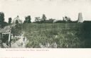
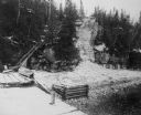
| Description: | Caption reads: "Old Light House at Long Tail Point, Green Bay, Wis." Built in 1859. A marshy area is in the foreground, and a long pier leads to the new li... |
| Date: | |
|---|---|
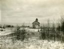
| Description: | Exterior view of the "Pottawatomie" lighthouse in snowy expanse of land, with the lake in the background. |
| Date: | 1910 |
|---|---|
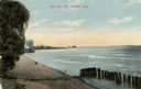
| Description: | View of the main pier and harbor lighthouse from the Lake Michigan shoreline. Caption reads: "Bay and Pier, Racine, Wis." |
| Date: | |
|---|---|
| Description: | La Pointe Light on Long Island (Apostle Islands), Chequamegon Bay, Lake Superior. |
| Date: | |
|---|---|
| Description: | The stairs and dock at the lighthouse on Rock Island. |
| Date: | 1916 |
|---|---|
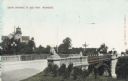
| Description: | South entrance to park. The bridge has stone lion sculptures on each of its corners, as well as ornate street lamps. A lighthouse and attached buildings ar... |
| Date: | 1947 |
|---|---|
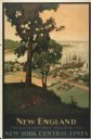
| Description: | An original lithograph promoting New York Central Lines railway and the area of New England, deemed "America's Historic Summerland" in the poster. Featurin... |

| Date: | |
|---|---|
| Description: | View along shoreline toward a lighthouse and homes standing on Rocky Point. There are several boats anchored at the shore and in the water. |

| Date: | 1896 |
|---|---|
| Description: | This hand-colored map shows counties, county seats, cities, towns, proposed and completed railroads, and U.S. Land Offices. Also included in the map are th... |

| Date: | 1880 |
|---|---|
| Description: | Map of Wisconsin including the eastern portions on Minnesota, Iowa, northern Illinois, and the western most portion of Michigan’s Upper Peninsula, showing ... |

| Date: | 1848 |
|---|---|
| Description: | Wisconsin became the thirtieth state in 1848. Drawn that same year, this map shows township lines, roads, villages, mills, railroads, prairies, swamps, can... |
| Date: | 1915 |
|---|---|
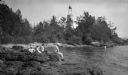
| Description: | Ferdinand Leonard (Fedy) Hotz, far left, sisters Helen, left, and Alice, sit with Thomas Toft on the rocky shore near the Baileys Harbor lighthouse. A rowb... |

| Date: | 1916 |
|---|---|
| Description: | This Wisconsin Conservation Commission map from 1916 shows Peninsula State Park in the Town of Gibraltar, Door County, Wisconsin. Depicted are open and pla... |

| Date: | 1916 |
|---|---|
| Description: | This version of a 1916 Wisconsin Conservation Commission map shows Peninsula State Park in the Town of Gibraltar, Door County, Wisconsin. Depicted are open... |

| Date: | 1896 |
|---|---|
| Description: | This 1896 map of Racine and Kenosha counties, Wisconsin, shows the township and range grid, towns, sections, cities, villages and post offices, roads, rail... |

| Date: | 1930 |
|---|---|
| Description: | Aerial view from over Moonlight Bay, looking east across Bues Point to Spike Horn Bay and Cana Island. The Cana Island Lighthouse is seen as a ship passes ... |
| Date: | 1913 |
|---|---|
| Description: | Hand-colored postcard showing the lighthouse and fog signal at Devil's Island in the Apostle Islands. Caption reads: "Apostle Islands, Wis. Devil's Island,... |
If you didn't find the material you searched for, our Library Reference Staff can help.
Call our reference desk at 608-264-6535 or email us at: