 Filter: Subject of lighthouses
Filter: Subject of land
Filter: Subject of lighthouses
Filter: Subject of land
| Date: | 1920 |
|---|---|
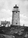
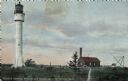
| Description: | A view of the Monhegan Island granite lighthouse, built in 1850 and automated in 1959, with the keeper's house close by, which was originally erected in 18... |
| Date: | 1918 |
|---|---|
| Description: | View across rocks toward the Mount Desert Rock granite lighthouse, established in 1830 and automated in 1977, located thirty miles out to sea on a treeless... |
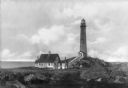
| Date: | |
|---|---|
| Description: | View across rocky ground and grass toward the Northern Lighthouse and the nearby cottage. A covered walkway leads from the house up to the entrance of the ... |
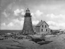
| Date: | 1908 |
|---|---|
| Description: | A view of the Prudence Island granite lighthouse, established in 1852 and automated in 1972, more commonly known locally as the Sandy Point Lighthouse. The... |

| Date: | |
|---|---|
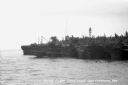
| Description: | View across water toward the Montauk Lighthouse, in Montauk Point State Park, a U.S. Government Reservation on Long Island. Several people are playing on t... |

| Date: | |
|---|---|
| Description: | View along shoreline toward a lighthouse and homes standing on Rocky Point. There are several boats anchored at the shore and in the water. |

| Date: | |
|---|---|
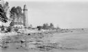
| Description: | A rocky coast is populated with homes, hotels, and a lighthouse. |
| Date: | 1934 |
|---|---|
| Description: | View from water of Devil's Island lighthouse located above sandstone caves and arches in the Apostle Islands of Lake Superior. Caption reads: "Devil's Isla... |

| Date: | 1896 |
|---|---|
| Description: | This hand-colored map shows counties, county seats, cities, towns, proposed and completed railroads, and U.S. Land Offices. Also included in the map are th... |

| Date: | 1880 |
|---|---|
| Description: | Map of Wisconsin including the eastern portions on Minnesota, Iowa, northern Illinois, and the western most portion of Michigan’s Upper Peninsula, showing ... |

| Date: | 1848 |
|---|---|
| Description: | Wisconsin became the thirtieth state in 1848. Drawn that same year, this map shows township lines, roads, villages, mills, railroads, prairies, swamps, can... |
| Date: | 1915 |
|---|---|
| Description: | Ferdinand Leonard (Fedy) Hotz, far left, sisters Helen, left, and Alice, sit with Thomas Toft on the rocky shore near the Baileys Harbor lighthouse. A rowb... |
| Date: | 1912 |
|---|---|
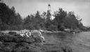
| Description: | The Cana Island lighthouse and keeper's house with the rocky shore in the foreground. |
| Date: | 1912 |
|---|---|
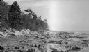
| Description: | Cana Island lighthouse is seen in the far distance across the stony shoreline along Lake Michigan. |

| Date: | 1908 |
|---|---|
| Description: | A detailed map of Michigan Island and Gull Island in the Apostle Islands group (T51N, R1W, 4 M) that shows sections, landowners, the Michigan Island Lighth... |

| Date: | 1916 |
|---|---|
| Description: | This Wisconsin Conservation Commission map from 1916 shows Peninsula State Park in the Town of Gibraltar, Door County, Wisconsin. Depicted are open and pla... |

| Date: | 1916 |
|---|---|
| Description: | This version of a 1916 Wisconsin Conservation Commission map shows Peninsula State Park in the Town of Gibraltar, Door County, Wisconsin. Depicted are open... |

| Date: | 1896 |
|---|---|
| Description: | This 1896 map of Racine and Kenosha counties, Wisconsin, shows the township and range grid, towns, sections, cities, villages and post offices, roads, rail... |

| Date: | 1930 |
|---|---|
| Description: | Aerial view from over Moonlight Bay, looking east across Bues Point to Spike Horn Bay and Cana Island. The Cana Island Lighthouse is seen as a ship passes ... |
| Date: | 1913 |
|---|---|
| Description: | Hand-colored postcard showing the lighthouse and fog signal at Devil's Island in the Apostle Islands. Caption reads: "Apostle Islands, Wis. Devil's Island,... |
If you didn't find the material you searched for, our Library Reference Staff can help.
Call our reference desk at 608-264-6535 or email us at: