 Filter: Subject of lighthouses
Filter: Subject of land use
Filter: Subject of water
Filter: Subject of lighthouses
Filter: Subject of land use
Filter: Subject of water

| Date: | 07 04 1931 |
|---|---|
| Description: | Inside of Saturday dinner menu for the "North American." Includes drawings of Niagara Falls, New York, Old Fort Mackinac Island, Michigan, Michigan Bouleva... |

| Date: | 1856 |
|---|---|
| Description: | The Ludemann's [also spelled Lueddemann] farm had been cultivated since the early 1850s by Mr. Ludemann, "a very pleasant Saxon with his very pleasant wife... |
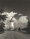
| Date: | 1954 |
|---|---|
| Description: | View down road towards the Fond du Lac lighthouse, built in 1933. There are cumulus clouds in the sky, and pine trees are lining the shore. |

| Date: | 1856 |
|---|---|
| Description: | View of Manitowoc from the north side. |

| Date: | 1937 |
|---|---|
| Description: | Lighthouse built by State Senator William Bray of Oshkosh, on a point where the Fox River empties into Lake Winnebago. |
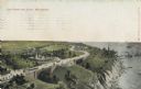
| Date: | |
|---|---|
| Description: | Elevated view with the lake on the right, with a number of boats near the shoreline. There is a long winding road through the park, including bridges, a fo... |
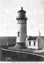
| Date: | |
|---|---|
| Description: | Elevated view of the century-old North Head Lighthouse, completed in 1898, built in response to a marked increase in the number of shipwrecks along the Pen... |
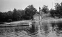
| Date: | 1920 |
|---|---|
| Description: | View from water of a man with a beard standing on a pier near a small boathouse. In the background is a lighthouse with keeper's house and outbuilding. |

| Date: | 1916 |
|---|---|
| Description: | This Wisconsin Conservation Commission map from 1916 shows Peninsula State Park in the Town of Gibraltar, Door County, Wisconsin. Depicted are open and pla... |

| Date: | 1916 |
|---|---|
| Description: | This version of a 1916 Wisconsin Conservation Commission map shows Peninsula State Park in the Town of Gibraltar, Door County, Wisconsin. Depicted are open... |

| Date: | 1896 |
|---|---|
| Description: | This 1896 map of Racine and Kenosha counties, Wisconsin, shows the township and range grid, towns, sections, cities, villages and post offices, roads, rail... |
| Date: | |
|---|---|
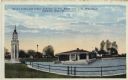
| Description: | Hand-colored postcard view of the lighthouse and boathouse at Bray's Point. Caption reads: "Bray's Point and Light, Junction of Fox River with Lake Winneba... |

| Date: | 1960 |
|---|---|
| Description: | This mid-20th century tourist brochure for Bayfield County, Wisconsin, includes a map of the county showing towns, cities and villages, highways and roads,... |

| Date: | 1941 |
|---|---|
| Description: | Elevated view of Sturgeon Bay in 1900. Sturgeon Bay Bridge spans the bay and several boats are on the water. A lighthouse sits on a small island in the bay... |

| Date: | 01 08 1958 |
|---|---|
| Description: | View of Two Rivers Harbor from shoreline towards Lake Michigan. Snow is on the ground, and a fence made of thick posts and cable is along the shoreline on ... |

| Date: | |
|---|---|
| Description: | Illustration of view across water towards a lighthouse and surrounding buildings. Caption reads: "U.S. Light House, Kenosha, Wis." |

| Date: | 1955 |
|---|---|
| Description: | Wind Point Lighthouse surrounded by outbuildings and framed by trees. Lake Michigan is in the distance. |
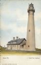
| Date: | 1952 |
|---|---|
| Description: | Text on front reads: "Racine, Wis.", "North Point Lighthouse". This is actually the Wind Point Lighthouse on Wind Point, located on the north end of Racine... |
If you didn't find the material you searched for, our Library Reference Staff can help.
Call our reference desk at 608-264-6535 or email us at: