 Filter: Subject of lighthouses
Filter: Subject of michigan, lake
Filter: Subject of land
Filter: Subject of lighthouses
Filter: Subject of michigan, lake
Filter: Subject of land
| Date: | 1915 |
|---|---|
| Description: | Colorized view of the Sherwood Point Lighthouse. Caption reads: "Sherwood Point Light House, Sturgeon Bay, Wis." |

| Date: | 1907 |
|---|---|
| Description: | The Ruins of the old Light House on Plum Island near Sturgeon Bay. Caption at bottom reads: "Ruins of Old Light House on Plum Island," "Made expressly for ... |
| Date: | 1910 |
|---|---|
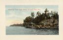
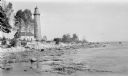
| Description: | View of the main pier and harbor lighthouse from the Lake Michigan shoreline. Caption reads: "Bay and Pier, Racine, Wis." |

| Date: | 1896 |
|---|---|
| Description: | This hand-colored map shows counties, county seats, cities, towns, proposed and completed railroads, and U.S. Land Offices. Also included in the map are th... |

| Date: | 1880 |
|---|---|
| Description: | Map of Wisconsin including the eastern portions on Minnesota, Iowa, northern Illinois, and the western most portion of Michigan’s Upper Peninsula, showing ... |

| Date: | 1848 |
|---|---|
| Description: | Wisconsin became the thirtieth state in 1848. Drawn that same year, this map shows township lines, roads, villages, mills, railroads, prairies, swamps, can... |
| Date: | 1915 |
|---|---|
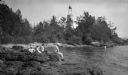
| Description: | Ferdinand Leonard (Fedy) Hotz, far left, sisters Helen, left, and Alice, sit with Thomas Toft on the rocky shore near the Baileys Harbor lighthouse. A rowb... |
| Date: | 1912 |
|---|---|
| Description: | The Cana Island lighthouse and keeper's house with the rocky shore in the foreground. |
| Date: | 1912 |
|---|---|
| Description: | Cana Island lighthouse is seen in the far distance across the stony shoreline along Lake Michigan. |

| Date: | 1930 |
|---|---|
| Description: | Aerial view from over Moonlight Bay, looking east across Bues Point to Spike Horn Bay and Cana Island. The Cana Island Lighthouse is seen as a ship passes ... |

| Date: | 1915 |
|---|---|
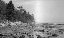
| Description: | Birch and evergreen trees line the rocky shore of Toft Point, with Cana Island and its lighthouse in the background. |

| Date: | 1920 |
|---|---|
| Description: | View from beach across Spike Horn Bay towards Cana Island and the Cana Island Light. |

| Date: | 1966 |
|---|---|
| Description: | A colored map depiction of Door County, Wisconsin, with pictorial highlights, titled: "Door County — Wisconsin's Air Conditioned Peninsula Playground." |

| Date: | |
|---|---|
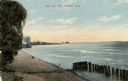
| Description: | Aerial view of harbor. In the foreground is a lighthouse and breakwaters. Bridges cross the harbor, and there are factory and industrial buildings near the... |

| Date: | 1905 |
|---|---|
| Description: | This map shows railroads, towns, lights, lights to be established, fog signals, light-vessels, lighted buoys, light-house depots, and light-house reservati... |

| Date: | 1902 |
|---|---|
| Description: | This map shows shoals near Waugoshance Point. Lighthouses are labeled. Depths are shown by soundings and tints. Relief is shown by hachures. Inset includes... |

| Date: | |
|---|---|
| Description: | Illustration of a view across water towards a lighthouse and adjoining dwelling. Small boats are moored in the harbor. Caption reads: "The Old Government L... |
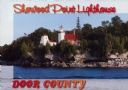
| Date: | 1963 |
|---|---|
| Description: | Text on front reads: "Sherwood Point Lighthouse, Door County, Wisconsin." On reverse: "Sherwood Point Lighthouse is near Potawatomi State Park, north of St... |
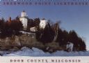
| Date: | 1963 |
|---|---|
| Description: | Text on front reads: "Sherwood Point Lighthouse, Door County." On reverse: "Built in 1883, the Sherwood Point Lighthouse marks the entrance into Sturgeon B... |
If you didn't find the material you searched for, our Library Reference Staff can help.
Call our reference desk at 608-264-6535 or email us at: