 Filter: Subject of lighthouses
Filter: Subject of michigan, lake
Filter: Subject of transportation
Filter: Subject of lighthouses
Filter: Subject of michigan, lake
Filter: Subject of transportation
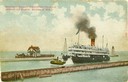
| Date: | |
|---|---|
| Description: | The screw passenger excursion vessel, "Christopher Columbus," being towed into the Milwaukee harbor past a breakwater. Milwaukee North Pier Inner Light in ... |
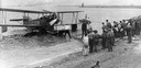
| Date: | 1929 |
|---|---|
| Description: | A Loening Amphibian, one of three such airplanes in which the Kohler Aviation Company provided passenger service from Milwaukee across Lake Michigan. |

| Date: | 1856 |
|---|---|
| Description: | The Ludemann's [also spelled Lueddemann] farm had been cultivated since the early 1850s by Mr. Ludemann, "a very pleasant Saxon with his very pleasant wife... |
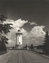
| Date: | 1954 |
|---|---|
| Description: | View down road towards the Fond du Lac lighthouse, built in 1933. There are cumulus clouds in the sky, and pine trees are lining the shore. |

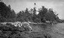
| Date: | 1953 |
|---|---|
| Description: | View across water towards the Sturgeon Bay Canal Lighthouse, with a group of people in a motorboat in the foreground. |

| Date: | 1915 |
|---|---|
| Description: | View of the Sturgeon Bay ship canal. Caption reads: "Sturgeon Bay Ship Canal." |

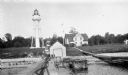
| Date: | 1913 |
|---|---|
| Description: | View of the canal. Caption reads: "The Canal, Stugeon[sic] Bay, Wis." |

| Date: | 1856 |
|---|---|
| Description: | View of Manitowoc from the north side. |
| Date: | 1910 |
|---|---|
| Description: | View of the main pier and harbor lighthouse from the Lake Michigan shoreline. Caption reads: "Bay and Pier, Racine, Wis." |
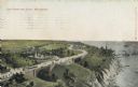
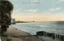
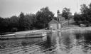
| Date: | |
|---|---|
| Description: | Elevated view with the lake on the right, with a number of boats near the shoreline. There is a long winding road through the park, including bridges, a fo... |
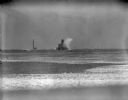
| Date: | |
|---|---|
| Description: | A large wave is breaking against the side of the Milwaukee breakwater lighthouse. There is a ship on the left, in the distance beyond the jetty. |

| Date: | 1896 |
|---|---|
| Description: | This hand-colored map shows counties, county seats, cities, towns, proposed and completed railroads, and U.S. Land Offices. Also included in the map are th... |

| Date: | 1880 |
|---|---|
| Description: | Map of Wisconsin including the eastern portions on Minnesota, Iowa, northern Illinois, and the western most portion of Michigan’s Upper Peninsula, showing ... |

| Date: | 1848 |
|---|---|
| Description: | Wisconsin became the thirtieth state in 1848. Drawn that same year, this map shows township lines, roads, villages, mills, railroads, prairies, swamps, can... |
| Date: | 1915 |
|---|---|
| Description: | Ferdinand Leonard (Fedy) Hotz, far left, sisters Helen, left, and Alice, sit with Thomas Toft on the rocky shore near the Baileys Harbor lighthouse. A rowb... |
| Date: | 1927 |
|---|---|
| Description: | View of the Plum Island rear range lighthouse from the end of the pier. The brick house was home to the lighthouse keeper and the first and second assistan... |
| Date: | 1920 |
|---|---|
| Description: | View from water of a man with a beard standing on a pier near a small boathouse. In the background is a lighthouse with keeper's house and outbuilding. |

| Date: | 1946 |
|---|---|
| Description: | Map of Kewaunee County, Wisconsin, shows towns, cities and villages, roads and highways, railroads, schools, lighthouses, place names, town divisions, comm... |
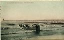
| Date: | 1908 |
|---|---|
| Description: | Group of men on a life saving crew launching a rowboat into Lake Michigan. A long pier with a lighthouse at the end bisects the horizon. Caption reads: "Li... |

| Date: | 1930 |
|---|---|
| Description: | Aerial view from over Moonlight Bay, looking east across Bues Point to Spike Horn Bay and Cana Island. The Cana Island Lighthouse is seen as a ship passes ... |
If you didn't find the material you searched for, our Library Reference Staff can help.
Call our reference desk at 608-264-6535 or email us at: