 Filter: Subject of lighthouses
Filter: Subject of recreation
Filter: Subject of lighthouses
Filter: Subject of recreation

| Date: | 1928 |
|---|---|
| Description: | Inside of Tuesday luncheon menu for the "South American." Includes drawings of Niagara Falls, New York, Old Fort Mackinac Island, Michigan, Michigan Boulev... |

| Date: | 1953 |
|---|---|
| Description: | View across water towards the Sturgeon Bay Canal Lighthouse, with a group of people in a motorboat in the foreground. |
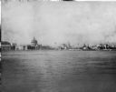
| Date: | 1893 |
|---|---|
| Description: | View of the Columbian Exposition grounds from Lake Michigan. |

| Date: | |
|---|---|
| Description: | View across water toward the Montauk Lighthouse, in Montauk Point State Park, a U.S. Government Reservation on Long Island. Several people are playing on t... |
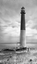
| Date: | |
|---|---|
| Description: | Barnegat Lighthouse was built in 1854 by the U.S. government. Oil-powered lights were originally installed in 1856 but were replaced by electric lights in ... |

| Date: | 1957 |
|---|---|
| Description: | Large Letter style postcard for Green Bay depicting various scenes in the letters that spell the name of the city. Caption reads: "Greetings from Green Bay... |

| Date: | 1916 |
|---|---|
| Description: | This Wisconsin Conservation Commission map from 1916 shows Peninsula State Park in the Town of Gibraltar, Door County, Wisconsin. Depicted are open and pla... |

| Date: | 1916 |
|---|---|
| Description: | This version of a 1916 Wisconsin Conservation Commission map shows Peninsula State Park in the Town of Gibraltar, Door County, Wisconsin. Depicted are open... |

| Date: | 1871 |
|---|---|
| Description: | Engraved view of Kenosha harbor. A group of men fish from a pier in the foreground while several boats float through the harbor. A tug is pulling a large s... |

| Date: | 1967 |
|---|---|
| Description: | This tourist brochure for Bayfield County, Wisconsin, from 1967 includes a map of the county showing towns, cities and villages, highways and roads, railro... |

| Date: | 1966 |
|---|---|
| Description: | A colored map depiction of Door County, Wisconsin, with pictorial highlights, titled: "Door County — Wisconsin's Air Conditioned Peninsula Playground." |

| Date: | 1938 |
|---|---|
| Description: | This map shows roads, parks, golf courses, airports, beaches, docks and harbors, lighthouses, and buoys within Winnebago County and parts of Waushara, Calu... |

| Date: | 1970 |
|---|---|
| Description: | This map shows roads, parks, swimming beaches, golf courses, yacht harbors, light houses, airports, public hunting grounds, waysides, schools, and fishing ... |
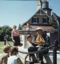
| Date: | 1969 |
|---|---|
| Description: | Three children and two adults are stand and sitting around an elderly man wearing a ship captains hat. He is holding a wooden model of a ship. The group of... |
| Date: | 1952 |
|---|---|
| Description: | Rawley Point Lighthouse, located in the Point Beach State Forest. It is 111 feet tall. |
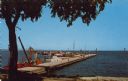
| Date: | 1958 |
|---|---|
| Description: | Text on reverse reads: "Yacht Basin on Lake Michigan. Sheboygan, Wisconsin." View from shore towards a long "L" shaped concrete dock with many boats moored... |
If you didn't find the material you searched for, our Library Reference Staff can help.
Call our reference desk at 608-264-6535 or email us at: