 Filter: Subject of lighthouses
Filter: Subject of streets
Filter: Subject of lighthouses
Filter: Subject of streets

| Date: | 1946 |
|---|---|
| Description: | Map of Kewaunee County, Wisconsin, shows towns, cities and villages, roads and highways, railroads, schools, lighthouses, place names, town divisions, comm... |

| Date: | 1950 |
|---|---|
| Description: | This map of Sturgeon Bay is part of the survey of the northern and northwestern lakes. The map shows lights, railroads, roads, and some public buildings. R... |

| Date: | 1857 |
|---|---|
| Description: | This map shows lot and block numbers, streets, railroad depots, locks, bridges, dams, canals, U.S. light house, college grounds, a steam boat landing, and ... |

| Date: | 12 22 1908 |
|---|---|
| Description: | Text reads: "Views of Racine, Wis." A collage of 12 postcards with views of buildings, landmarks and ships. |
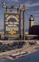
| Date: | 1973 |
|---|---|
| Description: | Text on sign reads: "Lighthouse on the Lake, Motel, Restaurant, Indoor Pool." On reverse: "Lighthouse Inn on the Lake. Highway 42, 1515 Memorial Drive, Two... |
If you didn't find the material you searched for, our Library Reference Staff can help.
Call our reference desk at 608-264-6535 or email us at: