 Filter: Subject of lighthouses
Filter: Subject of transportation
Filter: Subject of superior, lake
Filter: Subject of lighthouses
Filter: Subject of transportation
Filter: Subject of superior, lake

| Date: | 01 04 1862 |
|---|---|
| Description: | Engraving of the city of Superior and Lake Superior, also depicting railroad piers, Minnesota Point, and the steamboat "Star". The engraving appears on a l... |

| Date: | 1930 |
|---|---|
| Description: | Caption reads: "'The Old Standby' First Lighthouse Built at the Head of Lake Superior—Superior Entry — 1854 Keepers, Com. Saxton and Samuel Palmer." |
| Date: | |
|---|---|
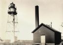
| Description: | La Pointe Light on Long Island (Apostle Islands), Chequamegon Bay, Lake Superior. |

| Date: | 1896 |
|---|---|
| Description: | This hand-colored map shows counties, county seats, cities, towns, proposed and completed railroads, and U.S. Land Offices. Also included in the map are th... |

| Date: | 1880 |
|---|---|
| Description: | Map of Wisconsin including the eastern portions on Minnesota, Iowa, northern Illinois, and the western most portion of Michigan’s Upper Peninsula, showing ... |

| Date: | 1891 |
|---|---|
| Description: | Photograph of a painting by May Conniff Frost showing the tugboat Record of the Inman Line pulling a lake schooner through rough waters into Superio... |

| Date: | 1960 |
|---|---|
| Description: | This mid-20th century tourist brochure for Bayfield County, Wisconsin, includes a map of the county showing towns, cities and villages, highways and roads,... |

| Date: | 1967 |
|---|---|
| Description: | This tourist brochure for Bayfield County, Wisconsin, from 1967 includes a map of the county showing towns, cities and villages, highways and roads, railro... |

| Date: | 1911 |
|---|---|
| Description: | This map of Duluth and Superior shows street car routes, railroads, ferries, some points of interest, and lighthouses. The bottom left of the map reads: "C... |

| Date: | 1905 |
|---|---|
| Description: | This map shows railroads, towns, lights, lights to be established, fog signals, light-vessels, lighted buoys, light-house depots, and light-house reservati... |

| Date: | 1963 |
|---|---|
| Description: | Text on front reads: "Wisconsin's North Coast." A man is standing on the side deck of a boat, and in the distance is the Raspberry Island Lighthouse with a... |

| Date: | 03 23 1915 |
|---|---|
| Description: | Text on front reads: "Steamship William E. Corey, entering Duluth and Superior Harbor, Wis." A steamship entering the harbor under the Aerial Lift Bridge, ... |
If you didn't find the material you searched for, our Library Reference Staff can help.
Call our reference desk at 608-264-6535 or email us at: