 Filter: Subject of lighthouses
Filter: Subject of water
Filter: Subject of rivers
Filter: Subject of lighthouses
Filter: Subject of water
Filter: Subject of rivers

| Date: | 1937 |
|---|---|
| Description: | Lighthouse built by State Senator William Bray of Oshkosh, on a point where the Fox River empties into Lake Winnebago. |
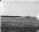
| Date: | 07 07 1898 |
|---|---|
| Description: | View across water of Sturgeon Bay. In the far distance are lighthouses, buildings, and barges along the shoreline. |
| Date: | |
|---|---|
| Description: | Color photographic postcard of the fisherman's dock taken from the harbor walkway. White boats are moored on either side of the Ahnapee River as it flows i... |

| Date: | 1957 |
|---|---|
| Description: | Large Letter style postcard for Green Bay depicting various scenes in the letters that spell the name of the city. Caption reads: "Greetings from Green Bay... |

| Date: | 1896 |
|---|---|
| Description: | This hand-colored map shows counties, county seats, cities, towns, proposed and completed railroads, and U.S. Land Offices. Also included in the map are th... |

| Date: | 1880 |
|---|---|
| Description: | Map of Wisconsin including the eastern portions on Minnesota, Iowa, northern Illinois, and the western most portion of Michigan’s Upper Peninsula, showing ... |

| Date: | 1848 |
|---|---|
| Description: | Wisconsin became the thirtieth state in 1848. Drawn that same year, this map shows township lines, roads, villages, mills, railroads, prairies, swamps, can... |

| Date: | 1931 |
|---|---|
| Description: | This U.S. Geological Survey map of Wisconsin shows counties, cities and villages, lighthouses, Indian reservations, military reservations, and bird and gam... |

| Date: | 1912 |
|---|---|
| Description: | This map from the U.S. General Land Office shows railroads, counties, cities and villages, rivers, lakes, U.S. Land Offices, Indian reservations, military ... |

| Date: | 1946 |
|---|---|
| Description: | Map of Kewaunee County, Wisconsin, shows towns, cities and villages, roads and highways, railroads, schools, lighthouses, place names, town divisions, comm... |
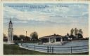
| Date: | |
|---|---|
| Description: | Hand-colored postcard view of the lighthouse and boathouse at Bray's Point. Caption reads: "Bray's Point and Light, Junction of Fox River with Lake Winneba... |

| Date: | 1967 |
|---|---|
| Description: | This tourist brochure for Bayfield County, Wisconsin, from 1967 includes a map of the county showing towns, cities and villages, highways and roads, railro... |

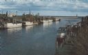
| Date: | 01 08 1958 |
|---|---|
| Description: | Elevated view from 8th Street Bridge over the Manitowoc River towards Lake Michigan. There is a lighthouse in the distance. Ice is floating on the water. A... |

| Date: | 01 07 1958 |
|---|---|
| Description: | View from the Second Street bridge over the icy Ahnapee River towards Lake Michigan. A lighthouse is at the end of a jetty in the far background. Boats are... |

| Date: | 01 08 1958 |
|---|---|
| Description: | View of Two Rivers Harbor from shoreline towards Lake Michigan. Snow is on the ground, and a fence made of thick posts and cable is along the shoreline on ... |

| Date: | |
|---|---|
| Description: | Aerial view of harbor. In the foreground is a lighthouse and breakwaters. Bridges cross the harbor, and there are factory and industrial buildings near the... |

| Date: | 1848 |
|---|---|
| Description: | This map shows lighthouses on part of Lake Superior, Green Bay, Lake Michigan, Lake Huron, Lake St. Clair, Lake Erie, Lake Ontario, the St. Lawrence River,... |

| Date: | 1905 |
|---|---|
| Description: | This map shows railroads, towns, lights, lights to be established, fog signals, light-vessels, lighted buoys, light-house depots, and light-house reservati... |

| Date: | 1908 |
|---|---|
| Description: | This map shows railroads, towns, lights, lights to be established, fog signals, light-vessels, lighted buoys, light-house depots, and light-house reservati... |

| Date: | 1857 |
|---|---|
| Description: | This map shows lot and block numbers, streets, railroad depots, locks, bridges, dams, canals, U.S. light house, college grounds, a steam boat landing, and ... |
If you didn't find the material you searched for, our Library Reference Staff can help.
Call our reference desk at 608-264-6535 or email us at: