Filter: Subject of manufacturing industries
Filter: Subject of bays
Filter: Subject of manufacturing industries
Filter: Subject of bays

| Date: | 1885 |
|---|---|
| Description: | View of the ore dock of the Milwaukee, Lake Shore, and Western Railroad. Large logs, buildings and a railroad bridge are in the foreground. |
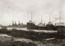
| Date: | 1914 |
|---|---|
| Description: | View of docks with ships tied up for the winter. The Reiss coal yard is in the background. |

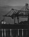
| Date: | 1961 |
|---|---|
| Description: | Aerial view of the Duluth-Superior bridge. |

| Date: | 1941 |
|---|---|
| Description: | Elevated view of Sturgeon Bay in 1900. Sturgeon Bay Bridge spans the bay and several boats are on the water. A lighthouse sits on a small island in the bay... |

| Date: | 1890 |
|---|---|
| Description: | This map shows lot and block numbers, established dock lines, docks, slips, railroads, streets, selected industrial buildings, sites for manufactories, and... |

| Date: | 1886 |
|---|---|
| Description: | This map shows lot and block numbers, sold lots, established dock lines, docks, slips, railroads, industrial buildings, streets, and the St. Louis Bay. |

| Date: | 1908 |
|---|---|
| Description: | This map shows streets, industrial buildings, a portion of Lake Superior and other lakes, bays, and rivers in portions of Duluth and Superior. Relief is sh... |

| Date: | 01 06 1958 |
|---|---|
| Description: | Ahnapee & Western Railway Bridge construction. View is from Highway Bridge. There are ships on the right side beyond the bridge. The forested shoreline cur... |
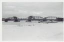
| Date: | 01 06 1958 |
|---|---|
| Description: | View from snowy shoreline of Highway Bridge, the east approach. The lake is frozen. Just beyond the shoreline a boat is moored at a landing, and an automob... |

| Date: | |
|---|---|
| Description: | Aerial view of harbors and bridge. Farm fields are on either side of the bridge. The city of Sturgeon Bay is in the distance. There are docks along the sho... |
| Date: | |
|---|---|
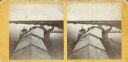
| Description: | Stereograph of an elevated view of Howard Side of Green Bay. View looks over roofs of long, industrial buildings near railroad tracks that run over the wat... |
| Date: | |
|---|---|
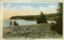
| Description: | Colored postcard view near the extreme northern point of Door County. There is a man standing on the left in a field of flowers looking at the bay. Fishing... |

| Date: | |
|---|---|
| Description: | Hand-colored postcard elevated view of buildings along the Fox River. Boats moored in the foreground. A train is passing by across the river. Old Fort Howa... |
If you didn't find the material you searched for, our Library Reference Staff can help.
Call our reference desk at 608-264-6535 or email us at: