 Filter: Subject of markets
Filter: Subject of human settlements
Filter: Subject of water
Filter: Subject of markets
Filter: Subject of human settlements
Filter: Subject of water

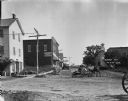
| Date: | |
|---|---|
| Description: | Elevated view of the second block of East Main Street showing the intersection of East Main and Webster streets. Businesses include the Argus Office and th... |
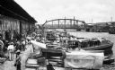
| Date: | |
|---|---|
| Description: | A view of small boats docked at a waterfront market in Tampico, Mexico showing a crowd of men in front of a waterfront warehouse, a steel bridge in the bac... |
| Date: | 1921 |
|---|---|
| Description: | View of men standing near a T-intersection. The three-story building on the left side of the intersection has a sandwich board advertising "Ice Cream." A m... |

| Date: | 1856 |
|---|---|
| Description: | This map shows the city as planned by the General Colonization Society, including streets, land parcels, two subdivisions of out-lots with graveyard, schoo... |

| Date: | 1789 |
|---|---|
| Description: | Map of New York City showing ward boundaries, ferries, streets, roads, swamps, ponds, and rivers. The properties of Lispinard, Byards, Jones, Rutgers, and ... |
If you didn't find the material you searched for, our Library Reference Staff can help.
Call our reference desk at 608-264-6535 or email us at: