Filter: Subject of men
Filter: Reproduction Rights of For Sale
Filter: Year of 1600-1699
Filter: Subject of engraving
Filter: Subject of men
Filter: Reproduction Rights of For Sale
Filter: Year of 1600-1699
Filter: Subject of engraving

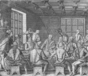
| Date: | 1655 |
|---|---|
| Description: | Frontispiece to Newe Welt vnd americanische Historien (1655). |
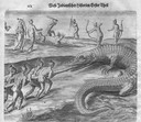
| Date: | 1655 |
|---|---|
| Description: | Engraving made after a painting by Jacques Le Moyne de Morgues (died 1588) while on the Laudonnière Expedition in Florida, ca. 1564. |
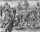
| Date: | 1655 |
|---|---|
| Description: | Engraving made after a painting by Jacques Le Moyne de Morgues (died 1588) while on the Laudonnière Expedition in Florida, ca. 1564. |
| Date: | 1655 |
|---|---|
| Description: | Engraving made after a painting by Jacques Le Moyne de Morgues (died 1588) while on the Laudonnière Expedition in Florida, ca. 1564. |
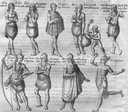
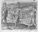
| Date: | 1655 |
|---|---|
| Description: | Depicts Indians encountered on the Barlowe and Amadas Expedition in Virgina, ca. 1584. |

| Date: | 1655 |
|---|---|
| Description: | Engraving made after a watercolor painting by John White during the Barlowe Expedition in Virginia, 1585-1587. |
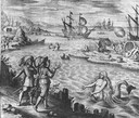
| Date: | 1655 |
|---|---|
| Description: | Scene of the Jamestown Settlement in Virginia, ca. 1614 showing men at the water's edge being beckoned by mermaids. |

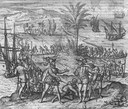
| Date: | 1655 |
|---|---|
| Description: | Christopher Columbus begins his first expedition, 1492. |
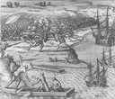
| Date: | 1655 |
|---|---|
| Description: | Scene on Hispaniola in 1500, when Columbus was forced to return to Spain after a new adminstrator had arrived. |
| Date: | 1655 |
|---|---|
| Description: | Scene from Christopher Columbus' fourth voyage, 1502-1504. |

| Date: | 1615 |
|---|---|
| Description: | Drawing of Native Americans chasing deer into an enclosure during a hunt. |

| Date: | 1698 |
|---|---|
| Description: | An illustration of two men looking out at Niagara Falls. The Niagara Falls in Jean Louis Hennepin’s A new discovery of a vast country in America (London: M... |

| Date: | 1696 |
|---|---|
| Description: | Engraved and hand-colored map of Ethiopia, from Blaeu's General Atlas. Map title is framed by a man and a woman, both wearing head turbans, who are standin... |

| Date: | 1627 |
|---|---|
| Description: | Map of North and South America showing settlements, rivers, lakes, mountains, islands and regions of the western hemisphere. It includes an inset map of Gr... |

| Date: | 1630 |
|---|---|
| Description: | One of the few maps by Dutch cartographer Willem Blaeu depicting the Americas, this map shows regions, settlements, islands, mountains, forests, rivers, an... |

| Date: | 1690 |
|---|---|
| Description: | A mysterious mixture of mythology, ancient geography, and late 17th century knowledge of the American coastline. This map shows North and South America, bu... |

| Date: | 1676 |
|---|---|
| Description: | Detailed map of North and South America. Cities, towns, forests, and mountains are shown pictorially. Duval labels regions, islands, cities, lakes, and Nat... |

| Date: | 1685 |
|---|---|
| Description: | A detailed map of the western hemisphere showing cities, settlements, Native American land, rivers, lakes, mountains, the Great Lakes, and California as an... |

| Date: | 1636 |
|---|---|
| Description: | Map of North America, divided into regions, and showing some rivers, lakes, settlements, cities, mountains, and Native American land. Of the Great Lakes on... |
If you didn't find the material you searched for, our Library Reference Staff can help.
Call our reference desk at 608-264-6535 or email us at: