 Filter: Subject of mountains
Filter: Subject of fishing
Filter: Subject of mountains
Filter: Subject of fishing
| Date: | 1976 |
|---|---|
| Description: | Color advertising photograph of a fisherman unloading gear from the rear of an International Scout II XL pickup near a mountain lake. |

| Date: | 1930 |
|---|---|
| Description: | Pictorial map of Glacier National Park, Montana and Waterton Lakes National Park, Alberta. Illustrated by Joe Scheurle, it depicts white people, American ... |

| Date: | 1930 |
|---|---|
| Description: | The back of the pictorial map titled Recreational Map of Glacier National Park, Montana: Waterton Lakes National Park, Alberta. 14 panels of text and photo... |
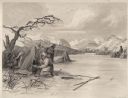
| Date: | 1884 |
|---|---|
| Description: | Small group of Native Americans spearing fish through ice on a river. Mountains can be seen in the background. |

| Date: | 1973 |
|---|---|
| Description: | An International Scout hauling a camper is parked next to a body of water. A man is fishing while a woman looks on from the banks of the water. |

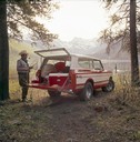
| Date: | 1977 |
|---|---|
| Description: | An International Scout II XLC parked on the shoreline of a lake. A man is using the hatchback of the truck to prepare for fishing, while another man in the... |

| Date: | 1759 |
|---|---|
| Description: | Map of north eastern Canada and parts of New England, showing settlements, cities, portages, Native American land, mountains, lakes, and rivers. The unusua... |

| Date: | 1783 |
|---|---|
| Description: | Map of the newly formed United States showing borders, regions, Native American land, cities, mountains, lakes, and rivers. It includes a small inset map o... |

| Date: | 02 04 1783 |
|---|---|
| Description: | One of the first and few maps to attempt to map the new boundaries of the United States and British territories during the preliminary treaty at the end of... |
If you didn't find the material you searched for, our Library Reference Staff can help.
Call our reference desk at 608-264-6535 or email us at: