 Filter: Subject of mountains
Filter: Subject of flowers
Filter: Subject of mountains
Filter: Subject of flowers
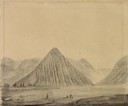
| Date: | 07 31 1849 |
|---|---|
| Description: | Bear River Peaks in Utah; sketched by Wilkins on his 151-day journey from Missouri to California on the Overland Trail (also known as the Oregon Trail). W... |
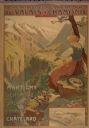
| Date: | 1900 |
|---|---|
| Description: | An original colored lithograph advertising the Chemins de Fer électrique du Valais à Chamonix (Electric Railways of Valais in Chamonix) railway. The poster... |

| Date: | |
|---|---|
| Description: | Christmas greeting card featuring a view of a mining town with smokestacks, gravel piles, houses, large buildings and distant mountains. Surrounding the ph... |

| Date: | 1938 |
|---|---|
| Description: | "Your 1939 Calendar" published for International Harvester farm equipment dealers. The cover features a painting of the Swiss Alps. |

| Date: | |
|---|---|
| Description: | A group of children stand along a fence near a row of cottages at the outskirts of town. In the far background is a mountain range. |
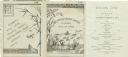
| Date: | 08 09 1879 |
|---|---|
| Description: | Dinner menu from the Steamer Japan of the Lake Superior Transit Company, with a panel including a stalk of bamboo, a dragonfly, and a butterfly, and... |
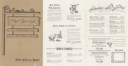
| Date: | |
|---|---|
| Description: | Front cover and middle menu pages from Robbie's Yodel Club in the New Glarus Hotel, with a sign featuring the restaurant logo's three figures: one holding ... |

| Date: | 1763 |
|---|---|
| Description: | Map of America and part of Canada including the borders of European claims after the French and Indian War. Cities, forts, Native American lands, rivers, l... |

| Date: | 1755 |
|---|---|
| Description: | Map of colonial America, showing the lands north of South Carolina and west of the Mississippi River. An inset map of the Carolinas and Georgia sits in the... |

| Date: | 1780 |
|---|---|
| Description: | Detailed map of America east of the Louisiana region. It shows forts, cities, borders and boundary lines, Native American land, the post road, mountains, w... |

| Date: | 1795 |
|---|---|
| Description: | Map of Connecticut showing counties, townships, cities, roads, islands, swamps, hills, mountains, lakes, rivers, reefs, and numerous other geographical and... |

| Date: | 1784 |
|---|---|
| Description: | Map of the southeastern region of America to just west of the Mississippi River. It shows borders, cities, towns, forts, Native American land, portages, mo... |

| Date: | 1776 |
|---|---|
| Description: | Map of Virginia and parts of Maryland and Delaware (written "De La War"). It shows borders, counties, cities, towns, plantations (marked by landowners name... |
If you didn't find the material you searched for, our Library Reference Staff can help.
Call our reference desk at 608-264-6535 or email us at: