 Filter: Subject of mountains
Filter: Subject of trails
Filter: Subject of mountains
Filter: Subject of trails
| Date: | 06 30 1849 |
|---|---|
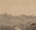
| Description: | The Black Hills sketched by Wilkins on his 151-day journey from Missouri to California on the Overland Trail (also known as the Oregon Trail). |
| Date: | 07 12 1849 |
|---|---|
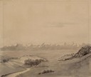
| Description: | Wilkins' first sighting of the Rocky Mountains; sketched by Wilkins on his 151-day journey from Missouri to California on the Overland Trail (also known as... |
| Date: | |
|---|---|
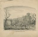
| Description: | "Conveying Provisions over the Ozark Mountains to the Army at Springfield, MO." Men on horseback are riding along a trail carrying supplies. |
| Date: | |
|---|---|
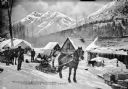
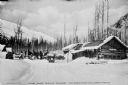
| Description: | Exterior view of Wortman's Road House, on the Fairbanks-Valdez trail in Alaska, with horse-drawn sleds and people and dogs in front of a number of building... |
| Date: | |
|---|---|
| Description: | View across snow-covered road towards several men and horses in front of the Dam Road House on the Fairbanks-Valdez Trail. Caption reads: "The Dam Road Hou... |
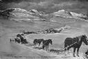
| Date: | |
|---|---|
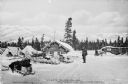
| Description: | View of men and sleds outside Yost's Road House on the Valdez-Fairbanks Trail. Mountains can be seen in the background. Caption reads: "Yost's Road House, ... |

| Date: | |
|---|---|
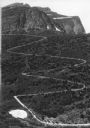
| Description: | View of a winding path with metal handrails leading up the side of a mountain to a fire lookout tower. |
| Date: | |
|---|---|
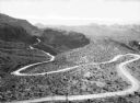
| Description: | Elevated view of an old trail winding through a desert landscape with mountains in the background in the vicinity of Oatman. |
| Date: | |
|---|---|
| Description: | Elevated view of a donkey train going up a zig-zag trail along the mountainside in Glacier National Park. |
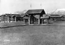
| Date: | |
|---|---|
| Description: | View of the Glacier Park Hotel entrance. View features a large archway surrounded by two smaller archways with paths passing under each. There are two flag... |
| Date: | |
|---|---|
| Description: | Men walk on the snow-covered Fairbanks-Valdez trail in Keystone Canyon. Caption reads: "Scene in Keystone Canyon, Fairbanks-Valdez Trail." |
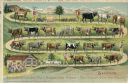
| Date: | |
|---|---|
| Description: | Color postcard of a Swiss farmer returning home with his animals. Many of the animals, and five of the shepherds, are labeled with a name. The path loops b... |

| Date: | 05 1961 |
|---|---|
| Description: | Colonel Bounchon's Lao Infantry men on mission to lay explosives behind lines. Three men are hiking up a hill. Rolling green mountains are visible in the b... |

| Date: | |
|---|---|
| Description: | View uphill of a team of oxen with a wagon stacked with lumber. In the background, men gather outside a general store located in the Raton Mountains, betwe... |
| Date: | |
|---|---|
| Description: | View downhill of a mule train with mail and freight in the mountains on the Fairbanks-Valdez Trail. Published by A.J. Johnson and Hall's Book Store. Copyr... |

| Date: | 1927 |
|---|---|
| Description: | A switchback path leading to Cap Carbon and the lighthouse perched near the summit of the peninsula. The lighthouse is built on top of a giant rock that pr... |

| Date: | 1949 |
|---|---|
| Description: | This pictorial map shows the United States west of the Mississippi, including Indian Tribes, historic trails, forts, trading posts, mountain ranges, lakes ... |

| Date: | 1794 |
|---|---|
| Description: | Extremely detailed map of the south-eastern states, south from Virginia and east of the Mississippi River. It shows roads and paths, cities, towns, forts, ... |

| Date: | 1795 |
|---|---|
| Description: | Map of Maine, showing a few cities, harbors, hills, mountains, lakes, and rivers. A road runs from Pownalboro south to Portsmouth harbor, and the boundary ... |

| Date: | |
|---|---|
| Description: | Repair work on Mount Lovcen to repair war damage caused by the Montenegrins. Vehicles are being pulled up a detour path on the mountain. |
If you didn't find the material you searched for, our Library Reference Staff can help.
Call our reference desk at 608-264-6535 or email us at: