 Filter: Subject of peninsulas
Filter: County of Douglas
Filter: Subject of peninsulas
Filter: County of Douglas

| Date: | 1883 |
|---|---|
| Description: | Bird's-eye map of Superior, county seat of Douglas County, on the shores of Lake Superior, with insets of points of interest. |

| Date: | 1990 |
|---|---|
| Description: | This map shows the Minnesota Point, Wisconsin Point, Hog Island, Baker's Island, Connors Point, Blatnik Bridge, Superior Bay, Allouez Bay, the Nemadji Rive... |
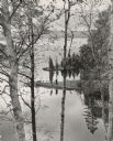
| Date: | 1955 |
|---|---|
| Description: | Elevated view towards a woman posing on a spit of land jutting into a lake, seen through birch trees in the spring. Caption reads: "Spring comes suddenly t... |

| Date: | 1932 |
|---|---|
| Description: | Text on front reads: "Fishermans Shack, Wis Point, Superior Wis." A man peers around the corner of his tar paper covered fishing shack on Wisconsin Point. ... |
If you didn't find the material you searched for, our Library Reference Staff can help.
Call our reference desk at 608-264-6535 or email us at: