 Filter: Subject of peninsulas
Filter: Subject of agriculture
Filter: Subject of peninsulas
Filter: Subject of agriculture
| Date: | 1926 |
|---|---|
| Description: | Elevated view of Picnic Point on Lake Mendota from the University of Wisconsin-Madison Soils building. |
| Date: | 1888 |
|---|---|
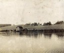
| Description: | View of shoreline along Picnic Point on the University of Wisconsin-Madison campus showing the home of Professor William Daniels, head of the Chemistry Dep... |

| Date: | 03 24 1913 |
|---|---|
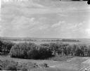
| Description: | Picnic Point from the University Farm fields, now known as Observatory Hill. |
| Date: | |
|---|---|
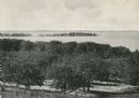
| Description: | Picnic Point from University drive, currently known as Observatory Hill. There are orchards in the foreground. |

| Date: | |
|---|---|
| Description: | An aerial view of both Picnic Point and Second Point looking toward the isthmus. Members of the Jackson Family had summer homes at Second Point at this tim... |

| Date: | 1930 |
|---|---|
| Description: | Aerial view over northern Door County, looking northeast across Europe Lake and Europe Bay toward Plum and Washington Islands. Farm fields and orchards con... |
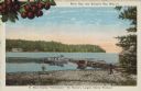
| Date: | 1950 |
|---|---|
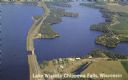
| Description: | Color photograph of an aerial view of Lake Wissota looking east on Highway 29. Many resorts are in the area. Lake Wissota is one of the largest man-made la... |

| Date: | 1942 |
|---|---|
| Description: | This pictorial bird's-eye-view map shows the United States of America with parts of Canada and Mexico. Landscape, trade, industry, points of interest, peop... |
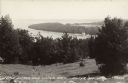
| Date: | 07 29 1946 |
|---|---|
| Description: | Text on front reads: "Little Sister and Sister Bays, Sister Bay, Wis." A view from a hill of the shoreline of Green Bay, Lake Michigan. |
| Date: | 1915 |
|---|---|
| Description: | Caption reads: "Sister Bay, near Sturgeon Bay, Wis." and "In Door County 'Cherryland,' the Nation's Largest Cherry Producer." Sister Bay from a rocky beach... |
If you didn't find the material you searched for, our Library Reference Staff can help.
Call our reference desk at 608-264-6535 or email us at: